IMAGES TAKEN NEAR TO
Church Street, WHITEHAVEN, CA28 7EX
Introduction
This page details the photographs taken nearby to Church Street, CA28 7EX by members of the Geograph project.
The Geograph project started in 2005 with the aim of publishing, organising and preserving representative images for every square kilometre of Great Britain, Ireland and the Isle of Man.

There are currently over 7.5m images from over14,400 individuals and you can help contribute to the project by visiting https://www.geograph.org.uk
Image Map
Images are licensed for reuse under creativecommons.org/licenses/by-sa/2.0
Notes
- Clicking on the map will re-center to the selected point.
- The higher the marker number, the further away the image location is from the centre of the postcode.
Image Listing (261 Images Found)
Images are licensed for reuse under creativecommons.org/licenses/by-sa/2.0
Image
Details
Distance
1
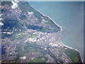
Whitehaven, harbour and marina
An aerial view from above the northwestern edge of the Lake District.
Image: © M J Richardson
Taken: 3 Jun 2015
0.02 miles
4
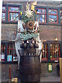
Clock at the Rum Story
The Kinetic Clock ticks away mechanically representing the story of rum from sugar cane to bottle.
Image: © Darrin Antrobus
Taken: 12 Apr 2009
0.06 miles
6
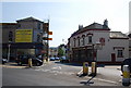
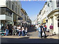
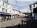
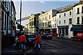
Duke Street
Looking towards the harbour
Image: © Stanley Walker
Taken: 18 Jun 2007
0.07 miles
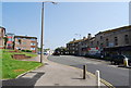
8
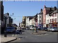
Duke Street, Whitehaven
An 1980s photo showing the coal conveyor(?) to the harbour looming over the town.
Image: © Simon Harmsworth
Taken: 27 Oct 1988
0.07 miles