IMAGES TAKEN NEAR TO
Chapel Street, WHITEHAVEN, CA28 7AX
Introduction
This page details the photographs taken nearby to Chapel Street, CA28 7AX by members of the Geograph project.
The Geograph project started in 2005 with the aim of publishing, organising and preserving representative images for every square kilometre of Great Britain, Ireland and the Isle of Man.

There are currently over 7.5m images from over14,400 individuals and you can help contribute to the project by visiting https://www.geograph.org.uk
Image Map (Loading...)


Getting Data...Please wait
Leaflet Map data © OpenStreetMap
Images are licensed for reuse under creativecommons.org/licenses/by-sa/2.0
Notes
- Clicking on the map will re-center to the selected point.
- The higher the marker number, the further away the image location is from the centre of the postcode.
Image Listing (325 Images Found)
Images are licensed for reuse under creativecommons.org/licenses/by-sa/2.0
Image
Details
Distance
1
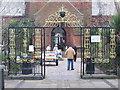
Gates to St. Nicholas Tower Chapel
A view looking northeast across Lowther Street to the entrance gates to St. Nicholas Tower Chapel.
Image: © Phil Williams
Taken: 18 Feb 2006
0.02 miles
2
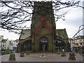
St. Nicholas Tower Chapel
A view looking southwest to St. Nicholas Tower Chapel, with Lowther Street in the background. The nave and sanctuary of the church were destroyed by fire on the afternoon of August 31, 1971.
Image: © Phil Williams
Taken: 18 Feb 2006
0.02 miles
3
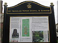
Information Board
A view of the information board giving details of the history of St. Nicholas Tower Chapel and Gardens.
Image: © Phil Williams
Taken: 18 Feb 2006
0.02 miles
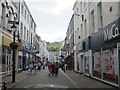
4
On Lowther Street
The words "Indian Blend" form part of the black painted mouldings on this photographic shop in Lowther Street, suggesting the original purpose of the building.
Image: © David Rogers
Taken: 22 Apr 2008
0.02 miles
5
On Lowther Street
The Whittington Cat on Lowther Street is one of about 41 Pubs, Inns and Taverns in Whitehaven.
Image: © David Rogers
Taken: 22 Apr 2008
0.02 miles
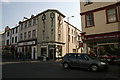
6
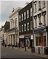
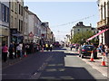
King Street, Whitehaven
King Street is the main shopping area in Whitehaven.
Image: © Graham Robson
Taken: 14 Jul 2012
0.03 miles
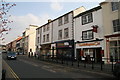
8
Lowther Street
In the mid 18th century the street was laid for Sir James Lowther the 1st Earl of Lonsdale's wish to view the shipping in his new harbour from his local seat of Whitehaven Castle which is back up the street and the line of the street formed the base from which the town grew on a grid plan to make Whitehaven the earliest planned town after the middle ages.
Image: © Stanley Walker
Taken: 18 Jun 2007
0.03 miles
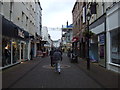
9
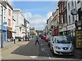
Lowther Street, Whitehaven
Looking along Lowther Street which is lined with shops and other businesses.
Image: © Graham Robson
Taken: 14 Jul 2012
0.03 miles