IMAGES TAKEN NEAR TO
Jubilee Road, WHITEHAVEN, CA28 6XJ
Introduction
This page details the photographs taken nearby to Jubilee Road, CA28 6XJ by members of the Geograph project.
The Geograph project started in 2005 with the aim of publishing, organising and preserving representative images for every square kilometre of Great Britain, Ireland and the Isle of Man.

There are currently over 7.5m images from over14,400 individuals and you can help contribute to the project by visiting https://www.geograph.org.uk
Image Map (Loading...)


Getting Data...Please wait
Leaflet Map data © OpenStreetMap
Images are licensed for reuse under creativecommons.org/licenses/by-sa/2.0
Notes
- Clicking on the map will re-center to the selected point.
- The higher the marker number, the further away the image location is from the centre of the postcode.
Image Listing (2 Images Found)
Images are licensed for reuse under creativecommons.org/licenses/by-sa/2.0
Image
Details
Distance
1
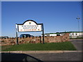
Whitehaven Golf Club
A new addition to the recreational facilities for Whitehaven.
Image: © John Holmes
Taken: 16 Nov 2005
0.24 miles
2
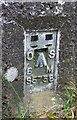
Benchmark on 'Standing Stones' trig point
Ordnance Survey flush bracket (serial identifier S5758) described on the OS Database as NX 9914 1809 FLUSH BRACKET FL BR S5758 STANDING STONES TP 143.256m ODN
Image: © Roger Templeman
Taken: 19 Apr 2018
0.25 miles