IMAGES TAKEN NEAR TO
Red Lonning Industrial Estate, WHITEHAVEN, CA28 6SJ
Introduction
This page details the photographs taken nearby to Red Lonning Industrial Estate, CA28 6SJ by members of the Geograph project.
The Geograph project started in 2005 with the aim of publishing, organising and preserving representative images for every square kilometre of Great Britain, Ireland and the Isle of Man.

There are currently over 7.5m images from over14,400 individuals and you can help contribute to the project by visiting https://www.geograph.org.uk
Image Map
Images are licensed for reuse under creativecommons.org/licenses/by-sa/2.0
Notes
- Clicking on the map will re-center to the selected point.
- The higher the marker number, the further away the image location is from the centre of the postcode.
Image Listing (5 Images Found)
Images are licensed for reuse under creativecommons.org/licenses/by-sa/2.0
Image
Details
Distance
1
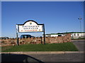
Whitehaven Golf Club
A new addition to the recreational facilities for Whitehaven.
Image: © John Holmes
Taken: 16 Nov 2005
0.11 miles
2
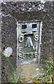
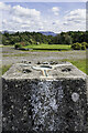
Benchmark on 'Standing Stones' trig point
Ordnance Survey flush bracket (serial identifier S5758) described on the OS Database as NX 9914 1809 FLUSH BRACKET FL BR S5758 STANDING STONES TP 143.256m ODN
Image: © Roger Templeman
Taken: 19 Apr 2018
0.14 miles
3
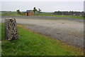
Whitehaven Golf Course
There is an Ordnance Survey trig point pillar Image at the entrance
Image: © Roger Templeman
Taken: 19 Apr 2018
0.15 miles
4
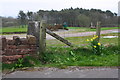
Triangulation pillar at entrance to Whitehaven Golf Course
Detailed information about the pillar is at http://trigpointing.uk/trig/6154 . The pillar's flush bracket benchmark Image is visible through the gap between the stone wall and the end wooden fence post
Image: © Roger Templeman
Taken: 19 Apr 2018
0.16 miles
5
Standing Stones Trigpoint and Golf Course, Whitehaven
Easy road side Trig http://www.trigpointinguk.com/trigs/trig-details.php?t=6154 near the golf course
Image: © Brian Deegan
Taken: 17 Sep 2022
0.17 miles