IMAGES TAKEN NEAR TO
Manesty Rise, WHITEHAVEN, CA28 6RY
Introduction
This page details the photographs taken nearby to Manesty Rise, CA28 6RY by members of the Geograph project.
The Geograph project started in 2005 with the aim of publishing, organising and preserving representative images for every square kilometre of Great Britain, Ireland and the Isle of Man.

There are currently over 7.5m images from over14,400 individuals and you can help contribute to the project by visiting https://www.geograph.org.uk
Image Map
Images are licensed for reuse under creativecommons.org/licenses/by-sa/2.0
Notes
- Clicking on the map will re-center to the selected point.
- The higher the marker number, the further away the image location is from the centre of the postcode.
Image Listing (10 Images Found)
Images are licensed for reuse under creativecommons.org/licenses/by-sa/2.0
Image
Details
Distance
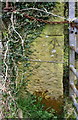
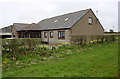
1
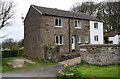
'Stonehowe'
There is an OS benchmark Image on the base quoin at the near corner, left hand face, of the house, where a stone wall abuts
Image: © Luke Shaw
Taken: 19 Apr 2018
0.08 miles
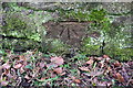
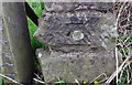
2
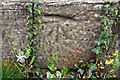
Benchmark on Stonehowe, Low Moresby
Ordnance Survey cut mark benchmark described on the Bench Mark Database at www.bench-marks.org.uk/bm113451
Image: © Luke Shaw
Taken: 19 Apr 2018
0.09 miles
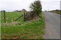
3
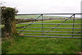
Field gateway from north side of minor road east of Low Moresby
There is an OS benchmark Image on the inside face of the gatepost at the left hand side of the gateway
Image: © Luke Shaw
Taken: 19 Apr 2018
0.13 miles
4
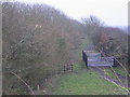
Railway without train.
The farmer seems to have made good use of the embankments when choosing the site for the stockpen.
Image: © John Holmes
Taken: 9 Dec 2005
0.13 miles
5
Benchmark on stone gatepost at field gateway east of Low Moresby
Image: © Luke Shaw
Taken: 19 Apr 2018
0.15 miles
6
Benchmark on south side of Low Moresby road
Ordnance Survey cut mark benchmark described on the Bench Mark Database at www.bench-marks.org.uk/bm113450
Image: © Luke Shaw
Taken: 19 Apr 2018
0.20 miles
7
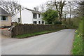
Minor road through Low Moresby
There is an OS benchmark Image on a stone at the base of the wall near the tree in front of the house
Image: © Luke Shaw
Taken: 19 Apr 2018
0.21 miles
8
Minor road approaching crossroads at High Farm
There is an OS benchmark Image on the near end, road face, of the wall on the left hand side of the road
Image: © Luke Shaw
Taken: 19 Apr 2018
0.23 miles
10
Benchmark on wall end on NW side of minor road SW of High Farm
Image: © Luke Shaw
Taken: 19 Apr 2018
0.24 miles