IMAGES TAKEN NEAR TO
Low Moresby, WHITEHAVEN, CA28 6RT
Introduction
This page details the photographs taken nearby to CA28 6RT by members of the Geograph project.
The Geograph project started in 2005 with the aim of publishing, organising and preserving representative images for every square kilometre of Great Britain, Ireland and the Isle of Man.

There are currently over 7.5m images from over14,400 individuals and you can help contribute to the project by visiting https://www.geograph.org.uk
Image Map
Images are licensed for reuse under creativecommons.org/licenses/by-sa/2.0
Notes
- Clicking on the map will re-center to the selected point.
- The higher the marker number, the further away the image location is from the centre of the postcode.
Image Listing (5 Images Found)
Images are licensed for reuse under creativecommons.org/licenses/by-sa/2.0
Image
Details
Distance
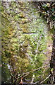
1
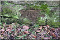
Benchmark on south side of Low Moresby road
Ordnance Survey cut mark benchmark described on the Bench Mark Database at www.bench-marks.org.uk/bm113450
Image: © Luke Shaw
Taken: 19 Apr 2018
0.00 miles
2
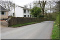
Minor road through Low Moresby
There is an OS benchmark Image on a stone at the base of the wall near the tree in front of the house
Image: © Luke Shaw
Taken: 19 Apr 2018
0.01 miles
3
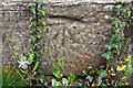
Benchmark on Stonehowe, Low Moresby
Ordnance Survey cut mark benchmark described on the Bench Mark Database at www.bench-marks.org.uk/bm113451
Image: © Luke Shaw
Taken: 19 Apr 2018
0.12 miles
4
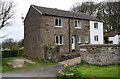
'Stonehowe'
There is an OS benchmark Image on the base quoin at the near corner, left hand face, of the house, where a stone wall abuts
Image: © Luke Shaw
Taken: 19 Apr 2018
0.12 miles
5
Benchmark on stone gatepost at field gateway near Ghyll Brow
Ordnance Survey cut mark benchmark described on the Bench Mark Database at www.bench-marks.org.uk/bm113449
Image: © Luke Shaw
Taken: 19 Apr 2018
0.25 miles