IMAGES TAKEN NEAR TO
Stamford Hill Avenue, WHITEHAVEN, CA28 6PT
Introduction
This page details the photographs taken nearby to Stamford Hill Avenue, CA28 6PT by members of the Geograph project.
The Geograph project started in 2005 with the aim of publishing, organising and preserving representative images for every square kilometre of Great Britain, Ireland and the Isle of Man.

There are currently over 7.5m images from over14,400 individuals and you can help contribute to the project by visiting https://www.geograph.org.uk
Image Map (Loading...)


Getting Data...Please wait
Leaflet Map data © OpenStreetMap
Images are licensed for reuse under creativecommons.org/licenses/by-sa/2.0
Notes
- Clicking on the map will re-center to the selected point.
- The higher the marker number, the further away the image location is from the centre of the postcode.
Image Listing (14 Images Found)
Images are licensed for reuse under creativecommons.org/licenses/by-sa/2.0
Image
Details
Distance
1
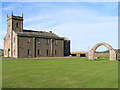
St Bridget's, Moresby
The free-standing arch is a striking feature and the site itself is adjacent to a Roman milefort.
Image: © Nigel Monckton
Taken: 1 Sep 2005
0.10 miles

3
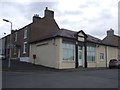
Former shop, High Lowca
Showing position of Postbox No. CA28 151.
See Image] for postbox.
Image: © JThomas
Taken: 23 Nov 2019
0.15 miles
4
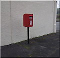
Elizabeth II postbox, High Lowca
Image: © JThomas
Taken: 23 Nov 2019
0.15 miles
5

Close up, Elizabeth II postbox, High Lowca
Postbox No. CA28 151.
See Image] for wider view.
Image: © JThomas
Taken: 23 Nov 2019
0.15 miles
6
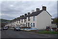
Terraced housing, High Lowca
Down the hill towards the coast.
Image: © JThomas
Taken: 23 Nov 2019
0.16 miles
7
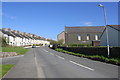
Road into Lowca from the south
There is an OS benchmark Image on the wall on the right hand side of the road on the nearside of the lamppost
Image: © Luke Shaw
Taken: 19 Apr 2018
0.16 miles
8

War Memorial
Memorial in the village of Lowca.
Image: © Wayland Smith
Taken: 25 May 2013
0.17 miles
9

Benchmark on wall on east side of road at East Croft Terrace
Ordnance Survey cut mark benchmark described on the Bench Mark Database at www.bench-marks.org.uk/bm113445
Image: © Luke Shaw
Taken: 19 Apr 2018
0.17 miles
