IMAGES TAKEN NEAR TO
Howgate, WHITEHAVEN, CA28 6PL
Introduction
This page details the photographs taken nearby to CA28 6PL by members of the Geograph project.
The Geograph project started in 2005 with the aim of publishing, organising and preserving representative images for every square kilometre of Great Britain, Ireland and the Isle of Man.

There are currently over 7.5m images from over14,400 individuals and you can help contribute to the project by visiting https://www.geograph.org.uk
Image Map
Images are licensed for reuse under creativecommons.org/licenses/by-sa/2.0
Notes
- Clicking on the map will re-center to the selected point.
- The higher the marker number, the further away the image location is from the centre of the postcode.
Image Listing (9 Images Found)
Images are licensed for reuse under creativecommons.org/licenses/by-sa/2.0
Image
Details
Distance
1
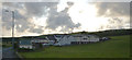
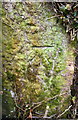
A beck seen from the B5306, Howgate, Moresby
The beck enters a tunnel under the road and emerges from it some distance to the north west just before flowing into Lowca Beck west.
Image: © habiloid
Taken: 13 Aug 2019
0.01 miles
5
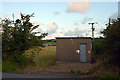
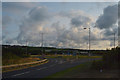
Electricity substation on the B5306 at Howgate, Moresby
Image: © habiloid
Taken: 13 Aug 2019
0.16 miles
6
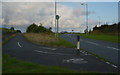
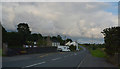
Cycle lane off B5306 leading to junction with A595
Image: © habiloid
Taken: 13 Aug 2019
0.18 miles
7
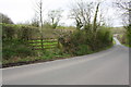
Minor road passing Moresby Wood
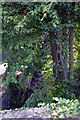
There is an OS benchmark Image on the far gatepost of the field gateway
Image: © Luke Shaw
Taken: 19 Apr 2018
0.20 miles
8
Benchmark on stone gatepost at field gateway near Ghyll Brow
Ordnance Survey cut mark benchmark described on the Bench Mark Database at www.bench-marks.org.uk/bm113449
Image: © Luke Shaw
Taken: 19 Apr 2018
0.20 miles