IMAGES TAKEN NEAR TO
Victoria Road, WHITEHAVEN, CA28 6JU
Introduction
This page details the photographs taken nearby to Victoria Road, CA28 6JU by members of the Geograph project.
The Geograph project started in 2005 with the aim of publishing, organising and preserving representative images for every square kilometre of Great Britain, Ireland and the Isle of Man.

There are currently over 7.5m images from over14,400 individuals and you can help contribute to the project by visiting https://www.geograph.org.uk
Image Map
Images are licensed for reuse under creativecommons.org/licenses/by-sa/2.0
Notes
- Clicking on the map will re-center to the selected point.
- The higher the marker number, the further away the image location is from the centre of the postcode.
Image Listing (24 Images Found)
Images are licensed for reuse under creativecommons.org/licenses/by-sa/2.0
Image
Details
Distance
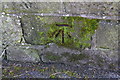
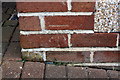
3
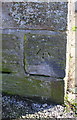
Benchmark on wall corner at #38 Victoria Road
Ordnance Survey cut mark benchmark levelled at 74.094m above Newlyn Datum
Image: © Roger Templeman
Taken: 9 Apr 2018
0.09 miles
4
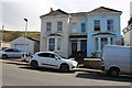
Nos. 38 and 40 Victoria Road
There is an OS benchmark Image on the corner of the wall
Image: © Roger Templeman
Taken: 9 Apr 2018
0.09 miles
5
Benchmark on wall at entrance to #61 Loop Road North
Ordnance Survey cut mark benchmark levelled at 70.872m above Newlyn Datum. There is more information at www.bench-marks.org.uk/bm112737
Image: © Roger Templeman
Taken: 9 Apr 2018
0.09 miles
6
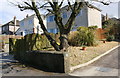
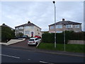
Entrance to #61 Loop Road North and adjacent houses
There is an OS benchmark Image on the wall about 2ft left of its right hand end which carries the house number, 61
Image: © Roger Templeman
Taken: 9 Apr 2018
0.09 miles
8
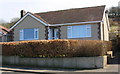
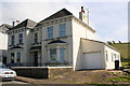
#100 Victoria Road, 'Moorside'
There is an OS benchmark Image on the front face of the bungalow
Image: © Roger Templeman
Taken: 9 Apr 2018
0.14 miles
9
Benchmark on #100 Victoria Road
Ordnance Survey cut mark benchmark levelled at 92.290m above Newlyn Datum
Image: © Roger Templeman
Taken: 9 Apr 2018
0.14 miles
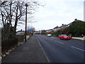
10
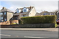
Housing on Loop Road North
There is an OS benchmark Image on the stone wall below the left hand edge of the hedge
Image: © Roger Templeman
Taken: 9 Apr 2018
0.16 miles