IMAGES TAKEN NEAR TO
Carvoran Way, CARLISLE, CA2 7XJ
Introduction
This page details the photographs taken nearby to Carvoran Way, CA2 7XJ by members of the Geograph project.
The Geograph project started in 2005 with the aim of publishing, organising and preserving representative images for every square kilometre of Great Britain, Ireland and the Isle of Man.

There are currently over 7.5m images from over14,400 individuals and you can help contribute to the project by visiting https://www.geograph.org.uk
Image Map
Images are licensed for reuse under creativecommons.org/licenses/by-sa/2.0
Notes
- Clicking on the map will re-center to the selected point.
- The higher the marker number, the further away the image location is from the centre of the postcode.
Image Listing (25 Images Found)
Images are licensed for reuse under creativecommons.org/licenses/by-sa/2.0
Image
Details
Distance
1
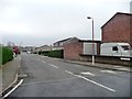
Chesterholm, Sandsfield Park, Carlisle
Looking southwards from Castlesteads Drive.
Image: © Christine Johnstone
Taken: 2 Nov 2015
0.04 miles
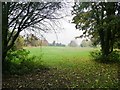
2
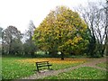
Autumn in the park, Carlisle
The popular wooded parkland along Parham Beck.
Image: © Christine Johnstone
Taken: 2 Nov 2015
0.11 miles
3
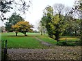
Trees along Parham Beck, Carlisle
A popular linear park.
Image: © Christine Johnstone
Taken: 2 Nov 2015
0.11 miles
4
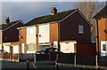
Nos. 188 and 186 Yewdale Road
There is an OS benchmark Image on the corner, road face, of the garage attached to the nearer house
Image: © Luke Shaw
Taken: 3 Dec 2019
0.11 miles
5
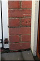
Benchmark on garage of 186 Yewdale Road
Ordnance Survey cut mark benchmark described on the Bench Mark Database at https://www.bench-marks.org.uk/bm82198
Image: © Luke Shaw
Taken: 3 Dec 2019
0.12 miles
6
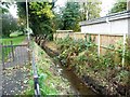
Small stream running south from Green Lane, Carlisle
Part of the Parham Beck drainage system.
Image: © Christine Johnstone
Taken: 2 Nov 2015
0.14 miles
7
The valley of Parham Beck, Carlisle
A 2km long finger of wooded parkland.
Image: © Christine Johnstone
Taken: 2 Nov 2015
0.14 miles
8
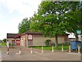
Yewdale Community Centre
The centre opened in 1992. It is situated between the residential estates of Sandsfield Park and Morton http://www.yewdalecommunitycentre.org.uk/ There is a car park with recycling skips to the right.
Image: © Rose and Trev Clough
Taken: 3 May 2009
0.18 miles
9
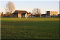
Yewdale Road Recreation Ground
Looking towards Yewdale Community Centre and Morton West shops
Image: © Roger Templeman
Taken: 3 Dec 2019
0.19 miles
10
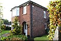
No. 86 Crown Road
There is an Ordnance Survey benchmark Image on the near corner, right hand face, of the house left of the black downpipe
Image: © Luke Shaw
Taken: 23 Oct 2020
0.19 miles