IMAGES TAKEN NEAR TO
Priorwood Close, CARLISLE, CA2 7TU
Introduction
This page details the photographs taken nearby to Priorwood Close, CA2 7TU by members of the Geograph project.
The Geograph project started in 2005 with the aim of publishing, organising and preserving representative images for every square kilometre of Great Britain, Ireland and the Isle of Man.

There are currently over 7.5m images from over14,400 individuals and you can help contribute to the project by visiting https://www.geograph.org.uk
Image Map (Loading...)


Getting Data...Please wait
Leaflet Map data © OpenStreetMap
Images are licensed for reuse under creativecommons.org/licenses/by-sa/2.0
Notes
- Clicking on the map will re-center to the selected point.
- The higher the marker number, the further away the image location is from the centre of the postcode.
Image Listing (21 Images Found)
Images are licensed for reuse under creativecommons.org/licenses/by-sa/2.0
Image
Details
Distance
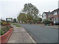
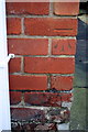
1
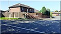
#28 Priorwood Close at Sandsfield Lane junction
Ordnance Survey documents indicate that a benchmark levelled at 46.165m above Newlyn Datum was verified in 1972 on a gatepost at this location
Image: © Roger Templeman
Taken: 4 Sep 2023
0.03 miles
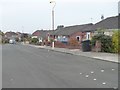
2
#1 Priorwood Close viewed across Sandsfield Lane
Image: © Luke Shaw
Taken: 4 Sep 2023
0.05 miles
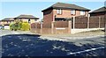
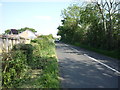
3
Houses on Holmrook Road, Carlisle
Three of the four semis have been extended over the garage.
Image: © Christine Johnstone
Taken: 2 Nov 2015
0.09 miles
4
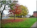
Autumn trees off Yewdale Road, Carlisle
The smaller trees are turning before the bigger ones.
Image: © Christine Johnstone
Taken: 2 Nov 2015
0.14 miles
5
Trees off Yewdale Road, Carlisle
In a patch of open space between Yewdale Road and Lodore Drive.
Image: © Christine Johnstone
Taken: 2 Nov 2015
0.14 miles
6
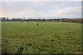
White and black sheep in field at Bunkershill
Image: © Roger Templeman
Taken: 3 Dec 2019
0.15 miles
8
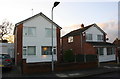
Nos. 72 and 70 Holmrook Road
There is an OS benchmark Image on the left hand side of the left hand house near its front corner
Image: © Luke Shaw
Taken: 3 Dec 2019
0.15 miles
9
Benchmark on 72 Holmrook Road
Ordnance Survey cut mark benchmark described on the Bench Mark Database at https://www.bench-marks.org.uk/bm80488
Image: © Luke Shaw
Taken: 3 Dec 2019
0.15 miles
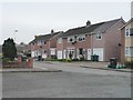
10
Unusual road markings, Holmrook Road, Carlisle
Perhaps indicating residents' parking places?
Image: © Christine Johnstone
Taken: 2 Nov 2015
0.16 miles