IMAGES TAKEN NEAR TO
Coniston Way, CARLISLE, CA2 7SJ
Introduction
This page details the photographs taken nearby to Coniston Way, CA2 7SJ by members of the Geograph project.
The Geograph project started in 2005 with the aim of publishing, organising and preserving representative images for every square kilometre of Great Britain, Ireland and the Isle of Man.

There are currently over 7.5m images from over14,400 individuals and you can help contribute to the project by visiting https://www.geograph.org.uk
Image Map
Images are licensed for reuse under creativecommons.org/licenses/by-sa/2.0
Notes
- Clicking on the map will re-center to the selected point.
- The higher the marker number, the further away the image location is from the centre of the postcode.
Image Listing (28 Images Found)
Images are licensed for reuse under creativecommons.org/licenses/by-sa/2.0
Image
Details
Distance
1
Houses on Yewdale Road, Carlisle
Opposite the junction with Skelwith Close.
Image: © Christine Johnstone
Taken: 11 Apr 2014
0.07 miles
2
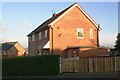
Nos. 2 and 4 Coalfell Avenue
Ordnance Survey documents indicate that a cut mark benchmark levelled at 39.660m above Newlyn Datum was verified in 1972 on the left hand corner of the nearer house (No. 2), beside the downpipe. See www.bench-marks.org.uk/bm113035
Image: © Roger Templeman
Taken: 3 Dec 2019
0.07 miles
3
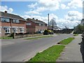
Yewdale Road, Carlisle
Looking west, parallel to Orton Road.
Image: © Christine Johnstone
Taken: 11 Apr 2014
0.08 miles
4
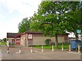
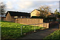
Yewdale Community Centre
The centre opened in 1992. It is situated between the residential estates of Sandsfield Park and Morton http://www.yewdalecommunitycentre.org.uk/ There is a car park with recycling skips to the right.
Image: © Rose and Trev Clough
Taken: 3 May 2009
0.08 miles
5

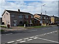
Hutton Way shops
There is a Chinese takeaway and Spar shop here. There used to be a Post Office, but it moved into the Spar for a while then closed in 2006. At the far end of the parade is a car park and Image .
Image: © Rose and Trev Clough
Taken: 3 May 2009
0.09 miles
6
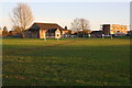
Yewdale Road Recreation Ground
Looking towards Yewdale Community Centre and Morton West shops
Image: © Roger Templeman
Taken: 3 Dec 2019
0.10 miles
7

The Border Reiver pub
The pub opened in 1971. If you walk through the bollards to the right, you come to a pedestrian area and Image .
Image: © Rose and Trev Clough
Taken: 3 May 2009
0.10 miles
8
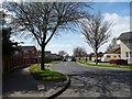
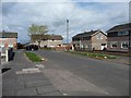
Yewdale Road, looking towards Orton Road, Carlisle
All four cul-de-sacs on the south side of Yewdale road are also called Yewdale Road.
Image: © Christine Johnstone
Taken: 11 Apr 2014
0.11 miles
9
Houses on the corner, Skelwith Close, Carlisle
This estate was built no later than the early 1970s, as it is on my 1974 OS map.
Image: © Christine Johnstone
Taken: 11 Apr 2014
0.11 miles
10
Footpath to Yewdale Road from Orton Road
There is an OS benchmark Image near the right hand end of the brick wall
Image: © Luke Shaw
Taken: 3 Dec 2019
0.12 miles