IMAGES TAKEN NEAR TO
Moorhouse Road, CARLISLE, CA2 7RJ
Introduction
This page details the photographs taken nearby to Moorhouse Road, CA2 7RJ by members of the Geograph project.
The Geograph project started in 2005 with the aim of publishing, organising and preserving representative images for every square kilometre of Great Britain, Ireland and the Isle of Man.

There are currently over 7.5m images from over14,400 individuals and you can help contribute to the project by visiting https://www.geograph.org.uk
Image Map
Images are licensed for reuse under creativecommons.org/licenses/by-sa/2.0
Notes
- Clicking on the map will re-center to the selected point.
- The higher the marker number, the further away the image location is from the centre of the postcode.
Image Listing (11 Images Found)
Images are licensed for reuse under creativecommons.org/licenses/by-sa/2.0
Image
Details
Distance
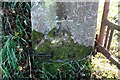
1
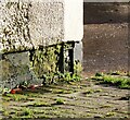
Benchmark on building at Cornhill Farm
Ordnance Survey flush bracket (serial Number 10983) benchmark described on the Bench Mark Database at www.bench-marks.org.uk/bm21680
See Image for 2023 photo of the bracket
Image: © Roger Templeman
Taken: 23 Oct 2020
0.01 miles
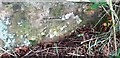
2
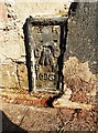
Benchmark on outbuilding at Cornhill Farm on SW side of Moorhouse Road
Ordnance Survey flush bracket (serial number 10983) levelled at 38.288m above Newlyn Datum in 1962 and verified in 1972
Image: © Roger Templeman
Taken: 6 Sep 2023
0.01 miles
3
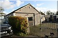
Building at Cornhill Farm
There is an Ordnance Survey flush bracket benchmark Image at the base of the far corner of the building, visible through the gateway at the junction of the two gates
Image: © Luke Shaw
Taken: 23 Oct 2020
0.01 miles
4
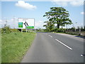
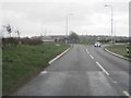
Approaching the A689
The B5307 towards Carlisle.
Image: © JThomas
Taken: 28 May 2016
0.05 miles
6
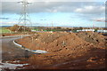
New Moorhouse Road Roundabout
The new Moorhouse Road roundabout under construction on the northern relief road around Carlisle. Due to open Spring 2012.
Image: © Andrew Peat
Taken: 13 Nov 2010
0.13 miles
7
Benchmark on gatepost at field gateway on NW side of rural road
Ordnance Survey cut mark benchmark which was levelled at 37.363m above Newlyn Datum and verified in 1972
Image: © Luke Shaw
Taken: 23 Oct 2020
0.23 miles
8
Benchmark on SW parapet of Hopsteps Bridge
Ordnance Survey cut mark benchmark levelled in 1962 at 31.423m above Newlyn Datum verified 1972
Image: © Roger Templeman
Taken: 2 Oct 2023
0.24 miles
10
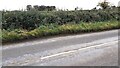
View across B5307 as it crosses Hopsteps Beck at Hopsteps Bridge
The east end of the southern parapet, with its Ordnance Survey benchmark Image can be seen through a hole in the hedge near the left hand edge of the image
Image: © Roger Templeman
Taken: 2 Oct 2023
0.24 miles