IMAGES TAKEN NEAR TO
Keld Road, CARLISLE, CA2 7QX
Introduction
This page details the photographs taken nearby to Keld Road, CA2 7QX by members of the Geograph project.
The Geograph project started in 2005 with the aim of publishing, organising and preserving representative images for every square kilometre of Great Britain, Ireland and the Isle of Man.

There are currently over 7.5m images from over14,400 individuals and you can help contribute to the project by visiting https://www.geograph.org.uk
Image Map (Loading...)


Getting Data...Please wait
Leaflet Map data © OpenStreetMap
Images are licensed for reuse under creativecommons.org/licenses/by-sa/2.0
Notes
- Clicking on the map will re-center to the selected point.
- The higher the marker number, the further away the image location is from the centre of the postcode.
Image Listing (34 Images Found)
Images are licensed for reuse under creativecommons.org/licenses/by-sa/2.0
Image
Details
Distance
1
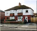
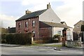
Nos. 24 and 22 Criffel Road
Ordnance Survey documents indicate that a cut mark benchmark levelled at 33.677m above Newlyn Datum was verified in 1955 on the side of the right hand house at its front corner, where the wooden fence abuts. See www.bench-marks.org.uk/bm114674
Image: © Roger Templeman
Taken: 8 Jan 2020
0.02 miles
2
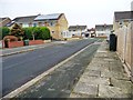
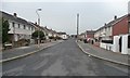
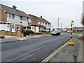
Keld Road, Belle Vue, Carlisle
Looking east from Acredale Road.
Image: © Christine Johnstone
Taken: 2 Nov 2015
0.04 miles
3
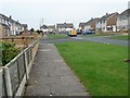
The cul-de-sac end of Keld Road, Belle Vue
No through route at the northern end of this suburban street.
Image: © Christine Johnstone
Taken: 2 Nov 2015
0.06 miles
4
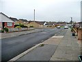
Acredale Road, Belle Vue, Carlisle
Looking south.
Image: © Christine Johnstone
Taken: 2 Nov 2015
0.06 miles
5
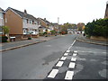
Birchdale Road, Belle Vue, Carlisle
Looking westwards from Keld Road.
Image: © Christine Johnstone
Taken: 2 Nov 2015
0.07 miles
6
Keld Road, Belle Vue, Carlisle
Looking south from the junction with Birchdale Road.
Image: © Christine Johnstone
Taken: 2 Nov 2015
0.08 miles
7
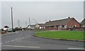
Bungalows on Kirkstead Road, Belle Vue
Between the junctions with Acredale Road and Moorhouse Road.
Image: © Christine Johnstone
Taken: 2 Nov 2015
0.09 miles
8
Acredale House on south side of Moorhouse Road
There is an Ordnance Survey benchmark Image on the bottom of the stone gatepost at the right hand side of the house entrance drive
Image: © Luke Shaw
Taken: 8 Jan 2020
0.09 miles
9
Temporary bus stop, Kirkstead Road, Belle Vue
On the east side of the road, for passengers heading into Carlisle.
Image: © Christine Johnstone
Taken: 2 Nov 2015
0.09 miles
10
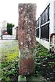
Benchmark on gatepost at Acredale House, Moorhouse Road
Ordnance Survey cut mark benchmark described on the Bench Mark Database at www.bench-marks.org.uk/bm114608
Image: © Luke Shaw
Taken: 8 Jan 2020
0.10 miles