IMAGES TAKEN NEAR TO
Siskin Court, CARLISLE, CA2 7PX
Introduction
This page details the photographs taken nearby to Siskin Court, CA2 7PX by members of the Geograph project.
The Geograph project started in 2005 with the aim of publishing, organising and preserving representative images for every square kilometre of Great Britain, Ireland and the Isle of Man.

There are currently over 7.5m images from over14,400 individuals and you can help contribute to the project by visiting https://www.geograph.org.uk
Image Map
Images are licensed for reuse under creativecommons.org/licenses/by-sa/2.0
Notes
- Clicking on the map will re-center to the selected point.
- The higher the marker number, the further away the image location is from the centre of the postcode.
Image Listing (61 Images Found)
Images are licensed for reuse under creativecommons.org/licenses/by-sa/2.0
Image
Details
Distance
1
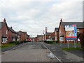
Turnstone Park
A recent housing development. It is built on the former Creighton Rugby Club ground, which was called Carr's Field.
Image: © Rose and Trev Clough
Taken: 27 Feb 2009
0.06 miles
2
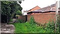
Footpath at south end of Engine Lonning
Image: © Roger Templeman
Taken: 12 Jul 2021
0.09 miles
3
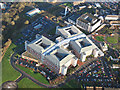
Cumberland Infirmary, Carlisle
The flagship of the national PFI programme was officially opened by the Rt. Hon. Tony Blair, Prime Minister, in June 2000.
http://www.visitcumbria.com/hospitals.htm
Image: © Simon Ledingham
Taken: 15 Dec 2004
0.10 miles
6
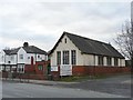
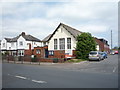
St. Barnabas Church Hall, Newtown Road
A stone set into the front of the building says "St. Barnabas Mission Chapel - This stone was laid by Mrs.A.N.Bowman - October 5th 1898". The current St. Barnabas Church (consecrated 1936) is not far away, on Shady Grove Road. On the right of the hall is Caxton Road (full of potholes), which leads to Newtown Industrial Estate.
Image: © Rose and Trev Clough
Taken: 27 Feb 2009
0.10 miles
7
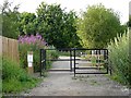
Entrance to Engine Lonning - recreation and wildlife area
Not a conventional park, Engine Lonning is a former rail yard that has been allowed to return to nature. It is managed by Carlisle City Council http://www.carlisle.gov.uk/leisure_and_culture/parks_and_open_spaces/parks_and_open_spaces/engine_lonning.aspx .
Image: © Rose and Trev Clough
Taken: 5 Jul 2009
0.11 miles
9
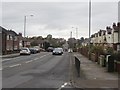
Newtown Road, Carlisle
Looking west along Newtown Road.
Image: © Graham Robson
Taken: 30 Oct 2014
0.11 miles
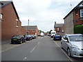
10
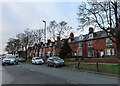
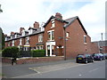
Newtown Road
This road, lined with red sandstone houses, is the main road out of Carlisle to the west.
Image: © Anne Burgess
Taken: 4 Jan 2023
0.11 miles