IMAGES TAKEN NEAR TO
Coledale Mews, CARLISLE, CA2 7NT
Introduction
This page details the photographs taken nearby to Coledale Mews, CA2 7NT by members of the Geograph project.
The Geograph project started in 2005 with the aim of publishing, organising and preserving representative images for every square kilometre of Great Britain, Ireland and the Isle of Man.

There are currently over 7.5m images from over14,400 individuals and you can help contribute to the project by visiting https://www.geograph.org.uk
Image Map
Images are licensed for reuse under creativecommons.org/licenses/by-sa/2.0
Notes
- Clicking on the map will re-center to the selected point.
- The higher the marker number, the further away the image location is from the centre of the postcode.
Image Listing (62 Images Found)
Images are licensed for reuse under creativecommons.org/licenses/by-sa/2.0
Image
Details
Distance
1
Junction in Coledale Meadows
A junction in Coledale Meadows (off Newtown Road) with Engine Lonning.
Image: © Roger Templeman
Taken: 17 Jul 2010
0.03 miles
2
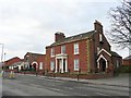
Coledale Hall, Newtown Road
Only the road and frontage of the building are in this gridsquare, the rest is in NY3856. Coledale Hall is Grade II* listed, built in 1810 for Henry Fawcett, MP for Carlisle http://www.imagesofengland.org.uk/Details/default.aspx?pid=2&id=386813 . The owner in 1846 was George Mould, successful railway contractor, who installed a lavish interior. It later became St. Mary's Home for Friendless Girls, then offices, and is now converted into flats.
Image: © Rose and Trev Clough
Taken: 27 Feb 2009
0.04 miles
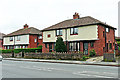
4
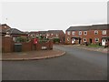
Coldedale Meadows, Carlisle
An estate comprising terraced and semi detached brick houses.
Image: © Graham Robson
Taken: 30 Oct 2014
0.04 miles
5
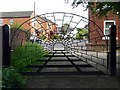
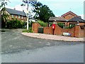
Engine Lonning - gate with 3D effect
By the corner of Harvey Street and Coledale Meadows. The gate was made by artist Chris Brammall, and installed April 2009 http://www.carlisle-city.gov.uk/council_and_democracy/council_news/archive,_april_2009/new_gateway_feature_put_in_pla.aspx . This is one end of the Engine Lonning footpath, which runs between housing estates to an area of public land by the River Eden http://www.geograph.org.uk/photo/1411767 .
Image: © Rose and Trev Clough
Taken: 5 Jul 2009
0.05 miles
6
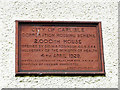
Plaque on Carlisle Corporation's 2,000th house
The house is in Newtown Road, for location see Image .
There is said to be a plaque in Harraby on the 4,000th house http://www.newsandstar.co.uk/news/Sense-of-pride-at-the-heart-of-Harraby-317773cc-02ef-498c-ace5-014430038823-ds , but we haven't been able to find it.
Image: © Rose and Trev Clough
Taken: 11 May 2015
0.05 miles
7
Carlisle's 2,000th council house
Located on Newtown Road. The house was built in 1929 - see Image .
A blog called 'Municipal Dreams' has a couple of very interesting articles about council housing in Carlisle https://municipaldreams.wordpress.com/2015/03/03/interwar_carlisle/ . It says Carlisle claimed to have built more council housing for its size than any town in England during the interwar period.
Image: © Rose and Trev Clough
Taken: 11 May 2015
0.05 miles
8
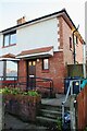
#163 Newtown Road
There is an Ordnance Survey benchmark (or replacement) Image on the right side of the house at its front corner (behind wheelie bin)
Image: © Luke Shaw
Taken: 29 Nov 2019
0.05 miles
9
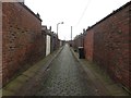
Back lane between Harvey Street and Newtown Road
The back lane between two rows of terraced houses. The houses on the left front onto Newtown Road, whilst the houses on the right are on Harvey Street.
Image: © Graham Robson
Taken: 30 Oct 2014
0.06 miles
10
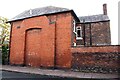
No. 106 Newtown Road (Engine Lonning face)
There is an Ordnance Survey benchmark Image in the bricks of the house wall left of the left hand branch of the chimney breast
Image: © Luke Shaw
Taken: 23 Oct 2020
0.06 miles