IMAGES TAKEN NEAR TO
Palmer Road, CARLISLE, CA2 7NE
Introduction
This page details the photographs taken nearby to Palmer Road, CA2 7NE by members of the Geograph project.
The Geograph project started in 2005 with the aim of publishing, organising and preserving representative images for every square kilometre of Great Britain, Ireland and the Isle of Man.

There are currently over 7.5m images from over14,400 individuals and you can help contribute to the project by visiting https://www.geograph.org.uk
Image Map
Images are licensed for reuse under creativecommons.org/licenses/by-sa/2.0
Notes
- Clicking on the map will re-center to the selected point.
- The higher the marker number, the further away the image location is from the centre of the postcode.
Image Listing (28 Images Found)
Images are licensed for reuse under creativecommons.org/licenses/by-sa/2.0
Image
Details
Distance
1
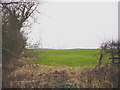
Farmland at Knockupworth
About 200 metres from the built-up housing of Carlisle City
Image: © Bob Jenkins
Taken: 6 Feb 2006
0.09 miles
2
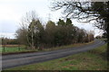
Burgh Road where it crosses Knockupworth Gill
Ordnance Survey records show that in 1971 there was a benchmark levelled at 23.754m above Newlyn Datum on a boundary stone on the road edge over the gill. See www.bench-marks.org.uk/bm114673
Image: © Luke Shaw
Taken: 8 Jan 2020
0.10 miles
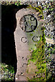
3
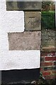
Benchmark on No. 109 Moorhouse Road (Beck Road face)
Ordnance Survey cut mark benchmark described on the Bench Mark Database at www.bench-marks.org.uk/bm114675
Image: © Luke Shaw
Taken: 8 Jan 2020
0.12 miles
4
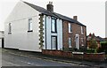
No. 109 Moorhouse Road at Beck Road junction
There is an Ordnance Survey benchmark Image on the 2nd quoin above the pavement of Beck Road, on the corner of the house at its junction with the brick wall
Image: © Luke Shaw
Taken: 8 Jan 2020
0.12 miles
5
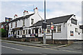
The Museum Inn
In Moorhouse Road, Belle Vue.
The pub has been here since the 1870s (Carlisle Encyclopedia http://www.carlisleshistory.co.uk/page35.htm ).
Image: © Rose and Trev Clough
Taken: 10 May 2014
0.12 miles
6
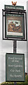
The Museum, Belle View - June 2017 (3)
The pub sign.
For information on this building, see: Image .
Image: © The Carlisle Kid
Taken: 25 Jun 2017
0.12 miles
7
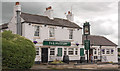
The Museum, Belle View - June 2017 (1)
Also known as the "Museum Inn", this is a late 18th Century building which originally doubled as both a farmhouse and pub. Later 20th Century additions are evident.
The pub was under State Management control from 9 August 1916 until sold to Scottish & Newcastle on 18 April 1973. Still trading.
See also: Image] and Image] .
The pub's history is best summarised on its own web site, which can be found: http://themuseumcarlisle.co.uk/ourhistory.html
Photograph is for record only - I have no connection with this business and all queries should be directed through the pub's web site.
Image: © The Carlisle Kid
Taken: 25 Jun 2017
0.13 miles
8
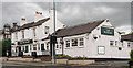
The Museum, Belle View - June 2017 (2)
For information on this building, see: Image] .
Image: © The Carlisle Kid
Taken: 25 Jun 2017
0.13 miles
9
Old Boundary Marker near Knockupworth Farm, Beaumont parish
Municipal Boundary Marker near an old canal bridge, and later railway bridge, near Knockupworth Farm, Beaumont parish. Rescued by the farmer in 2012 when the bypass was built, presumably from the Carlisle and Beaumont boundary at NY3707956488.
Milestone Society National ID: CU_CCB3
Image: © Colin Smith
Taken: 4 Jul 2010
0.15 miles
10
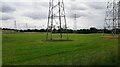
A 'forest' of electricity pylons from SW side of River Eden
Image: © Roger Templeman
Taken: 12 Jul 2021
0.16 miles