IMAGES TAKEN NEAR TO
Bardsley Street, CARLISLE, CA2 7LP
Introduction
This page details the photographs taken nearby to Bardsley Street, CA2 7LP by members of the Geograph project.
The Geograph project started in 2005 with the aim of publishing, organising and preserving representative images for every square kilometre of Great Britain, Ireland and the Isle of Man.

There are currently over 7.5m images from over14,400 individuals and you can help contribute to the project by visiting https://www.geograph.org.uk
Image Map
Images are licensed for reuse under creativecommons.org/licenses/by-sa/2.0
Notes
- Clicking on the map will re-center to the selected point.
- The higher the marker number, the further away the image location is from the centre of the postcode.
Image Listing (53 Images Found)
Images are licensed for reuse under creativecommons.org/licenses/by-sa/2.0
Image
Details
Distance
1
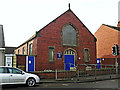
Newtown Methodist Church
Located on Newtown Road.
Image: © Rose and Trev Clough
Taken: 16 Feb 2015
0.04 miles
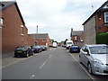
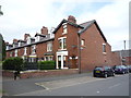
2
Shady Grove Road, Carlisle
Looking along Shady Grove Road, a long, but quiet residential street lined with semi detached houses.
Image: © Graham Robson
Taken: 30 Oct 2014
0.06 miles
3
Carlisle West Community Fire Station
Cumbria Fire and Rescue Service opened two new fire stations in Carlisle in 2012. This one is at Brookside in Raffles. The other is at Eastern Way, Durranhill Image
The firefighters vacated their old premises in Warwick Street Image, which has since been converted to an arts centre.
Image: © Rose and Trev Clough
Taken: 11 May 2015
0.06 miles
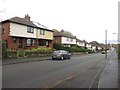
4
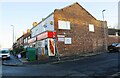
One stop food store #227 Newtown Road and neighbouring houses
The buildings are at the Shady Grove Road junction. There is an Ordnance Survey benchmark Image on a corner stone of the shop below the Shady Grove Road name sign.
Image: © Luke Shaw
Taken: 29 Nov 2019
0.06 miles
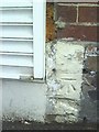
5
Benchmark on side of #106 Newtown Road
Ordnance Survey cut mark benchmark above the pavement of Coledale Meadows. More information about the mark may be found on the Bench Mark Database at http://www.bench-marks.org.uk/bm34895
Image: © Roger Templeman
Taken: 17 Jul 2010
0.06 miles
6
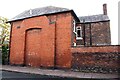
No. 106 Newtown Road (Engine Lonning face)
There is an Ordnance Survey benchmark Image in the bricks of the house wall left of the left hand branch of the chimney breast
Image: © Luke Shaw
Taken: 23 Oct 2020
0.06 miles
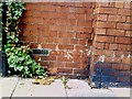
7
Benchmark on #227 Newtown Road
Ordnance Survey cut mark benchmark on the side of Mills Local Store above pavement of Shadygrove Road. The shuttering at the left of the picture is on the side of an ATM machine. More detail on the benchmark can be found at http://www.bench-marks.org.uk/bm34899.
Image: © Roger Templeman
Taken: 17 Jul 2010
0.07 miles
9
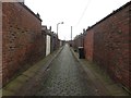
Back lane between Harvey Street and Newtown Road
The back lane between two rows of terraced houses. The houses on the left front onto Newtown Road, whilst the houses on the right are on Harvey Street.
Image: © Graham Robson
Taken: 30 Oct 2014
0.08 miles