IMAGES TAKEN NEAR TO
Brookside Place, CARLISLE, CA2 7JW
Introduction
This page details the photographs taken nearby to Brookside Place, CA2 7JW by members of the Geograph project.
The Geograph project started in 2005 with the aim of publishing, organising and preserving representative images for every square kilometre of Great Britain, Ireland and the Isle of Man.

There are currently over 7.5m images from over14,400 individuals and you can help contribute to the project by visiting https://www.geograph.org.uk
Image Map
Images are licensed for reuse under creativecommons.org/licenses/by-sa/2.0
Notes
- Clicking on the map will re-center to the selected point.
- The higher the marker number, the further away the image location is from the centre of the postcode.
Image Listing (55 Images Found)
Images are licensed for reuse under creativecommons.org/licenses/by-sa/2.0
Image
Details
Distance
2
Newtown Post Office
Showing position of Postbox No. CA2 76.
See Image] for postbox.
Image: © JThomas
Taken: 28 May 2016
0.06 miles
3

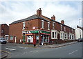
Newtown Road
Road junction of Bower Street with Newtown Road including Post Office.
Image: © Roger Templeman
Taken: 17 Jul 2010
0.07 miles
4
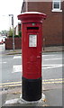
George V postbox in front of Newtown Post Office
Postbox No. CA2 76.
See Image] for context.
Image: © JThomas
Taken: 28 May 2016
0.07 miles
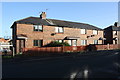
5
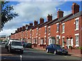
Houses of Newtown Road (#107 nearest) at Bower Street junction
There is an OS benchmark behind the green cabinet at the junction of the house and its front side brick wall: see https://www.bench-marks.org.uk/bm34891
Image: © Luke Shaw
Taken: 3 Jan 2020
0.07 miles
6
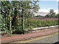
Gate to abandoned bowling green, Bright Street
For information see Image .
Image: © Rose and Trev Clough
Taken: 27 Aug 2016
0.07 miles
7
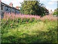
Overgrown bowling green
Situated between Bright Street (left) and Wood Street, off Newtown Road.
The site is owned by Carlisle City Council - looks like it's been neglected for years.
Image: © Rose and Trev Clough
Taken: 27 Aug 2016
0.08 miles
8
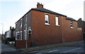
Nos. 63-69 (odds) Bower Street
There is an OS benchmark Image on the side of the left hand house near its front corner
Image: © Roger Templeman
Taken: 3 Jan 2020
0.08 miles
9

Benchmark on #63 Bower Street
Ordnance Survey cut mark benchmark on the side of the house described in detail on the Bench Mark Database at http://www.bench-marks.org.uk/bm34892
Image: © Roger Templeman
Taken: 17 Jul 2010
0.08 miles
10
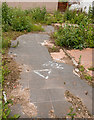
Site of "Pedestrian Arms" pub, Newtown Road - June 2017 (3)
Little remains of the former "Pedestrian Arms" - period photographs suggest these tiles leading away from Newtown Road may have been at the pub entrance.
For information on the pub, see: Image] .
Image: © The Carlisle Kid
Taken: 25 Jun 2017
0.08 miles