IMAGES TAKEN NEAR TO
Newtown Close, CARLISLE, CA2 7EH
Introduction
This page details the photographs taken nearby to Newtown Close, CA2 7EH by members of the Geograph project.
The Geograph project started in 2005 with the aim of publishing, organising and preserving representative images for every square kilometre of Great Britain, Ireland and the Isle of Man.

There are currently over 7.5m images from over14,400 individuals and you can help contribute to the project by visiting https://www.geograph.org.uk
Image Map
Images are licensed for reuse under creativecommons.org/licenses/by-sa/2.0
Notes
- Clicking on the map will re-center to the selected point.
- The higher the marker number, the further away the image location is from the centre of the postcode.
Image Listing (59 Images Found)
Images are licensed for reuse under creativecommons.org/licenses/by-sa/2.0
Image
Details
Distance
1
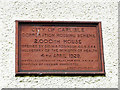
Plaque on Carlisle Corporation's 2,000th house
The house is in Newtown Road, for location see Image .
There is said to be a plaque in Harraby on the 4,000th house http://www.newsandstar.co.uk/news/Sense-of-pride-at-the-heart-of-Harraby-317773cc-02ef-498c-ace5-014430038823-ds , but we haven't been able to find it.
Image: © Rose and Trev Clough
Taken: 11 May 2015
0.06 miles
2
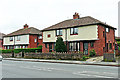
Carlisle's 2,000th council house
Located on Newtown Road. The house was built in 1929 - see Image .
A blog called 'Municipal Dreams' has a couple of very interesting articles about council housing in Carlisle https://municipaldreams.wordpress.com/2015/03/03/interwar_carlisle/ . It says Carlisle claimed to have built more council housing for its size than any town in England during the interwar period.
Image: © Rose and Trev Clough
Taken: 11 May 2015
0.06 miles
3
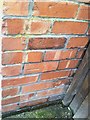
Benchmark at #163 Newtown Road
Horizontal cut in a brick at the position where there should be an Ordnance Survey cut mark benchmark. Suspect the bricks have been replaced with an attempt made to preserve the height of the cut mark. See the Bench Mark Database at http://www.bench-marks.org.uk/bm34894 for a description of the benchmark.
Image: © Roger Templeman
Taken: 17 Jul 2010
0.06 miles
4
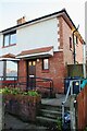
#163 Newtown Road
There is an Ordnance Survey benchmark (or replacement) Image on the right side of the house at its front corner (behind wheelie bin)
Image: © Luke Shaw
Taken: 29 Nov 2019
0.07 miles
5
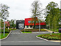
Carlisle West Community Fire Station
Cumbria Fire and Rescue Service opened two new fire stations in Carlisle in 2012. This one is at Brookside in Raffles. The other is at Eastern Way, Durranhill Image
The firefighters vacated their old premises in Warwick Street Image, which has since been converted to an arts centre.
Image: © Rose and Trev Clough
Taken: 11 May 2015
0.07 miles
6
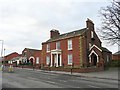
Coledale Hall, Newtown Road
Only the road and frontage of the building are in this gridsquare, the rest is in NY3856. Coledale Hall is Grade II* listed, built in 1810 for Henry Fawcett, MP for Carlisle http://www.imagesofengland.org.uk/Details/default.aspx?pid=2&id=386813 . The owner in 1846 was George Mould, successful railway contractor, who installed a lavish interior. It later became St. Mary's Home for Friendless Girls, then offices, and is now converted into flats.
Image: © Rose and Trev Clough
Taken: 27 Feb 2009
0.07 miles
7
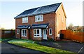
Nos. 83 and 85 Brookside
Ordnance Survey records show that a benchmark levelled at 24.776m above Newlyn Datum was verified in 1972 on the eastern house of a block of four houses at this location, apparently demolished and replaced by this pair of semis. See www.bench-marks.org.uk/bm103050
Image: © Luke Shaw
Taken: 29 Nov 2019
0.08 miles
8
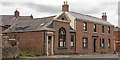
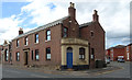
Former "Green Dragon" pub, Newtown Road - June 2017 (2)
For information on this building, see: Image] .
Image: © The Carlisle Kid
Taken: 25 Jun 2017
0.08 miles
9
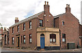
Former "Green Dragon" pub, Newtown Road - June 2017 (1)
The "Green Dragon" was built in two stages - the original pub being the building on the right in this view and is believed constructed circa 1806. In 1860, the pub was extended out to the Newtown Road, giving the appearance seen here. It was acquired by the State Management Scheme in 1916 (possibly August or September) and sold to John Smiths Brewing Group on 7 May 1973. The pub closed in 1998 and is now a private dwelling.
Apparently, the "Green Dragon" had a reputation as Carlisle's "roughest" pub - certainly its history is not without incident. On 3 September 1847, a man was killed by the landlord's "tame" bear, while a shotgun was blasted at a pub window on 1 April 1985. A landlord was declared bankrupt on 6 March 1997 while a 1999 reopening attempt failed due to the premises being known as a "notorious troublespot".
See also: Image] .
Image: © The Carlisle Kid
Taken: 25 Jun 2017
0.08 miles
10
Corner of Newtown Road (B5307) and Bellgarth Road, Carlisle
Image: © habiloid
Taken: 1 Aug 2016
0.09 miles