IMAGES TAKEN NEAR TO
Ashley Street, CARLISLE, CA2 7BD
Introduction
This page details the photographs taken nearby to Ashley Street, CA2 7BD by members of the Geograph project.
The Geograph project started in 2005 with the aim of publishing, organising and preserving representative images for every square kilometre of Great Britain, Ireland and the Isle of Man.

There are currently over 7.5m images from over14,400 individuals and you can help contribute to the project by visiting https://www.geograph.org.uk
Image Map
Images are licensed for reuse under creativecommons.org/licenses/by-sa/2.0
Notes
- Clicking on the map will re-center to the selected point.
- The higher the marker number, the further away the image location is from the centre of the postcode.
Image Listing (93 Images Found)
Images are licensed for reuse under creativecommons.org/licenses/by-sa/2.0
Image
Details
Distance
1
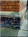
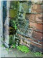
Benchmark on School
Ordnance Survey cut mark benchmark on school. The mark is described on the Bench Mark Database at http://www.bench-marks.org.uk/bm30957.
Image: © Roger Templeman
Taken: 17 Jul 2010
0.03 miles
2
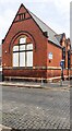
Caldew Lea Primary School at Ashley Street / Head Street junction
There is an Ordnance Survey benchmark Image on the near corner, left hand face, of the school
Image: © Roger Templeman
Taken: 12 Jul 2021
0.04 miles
3
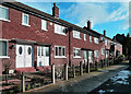
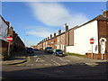
Granville Road
An attractive red brick row in central Carlisle.
Image: © Mary and Angus Hogg
Taken: 31 Jan 2015
0.05 miles
5
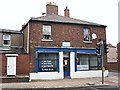
The last laundrette in town?
Poly Clean, Wigton Road.
In September 2013, this was the only laundrette I could find in Carlisle. In the early 2000s there were at least two more, in Furze Street (now Bargain Booze) and Beaconsfield Street (demolished).
Image: © Rose and Trev Clough
Taken: 24 Sep 2013
0.07 miles
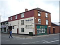
6
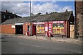
Newtown Garage and Port Road Stores
Image: © Rose and Trev Clough
Taken: 8 Sep 2011
0.07 miles
8
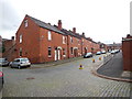
Carlisle - Head Street
Old red brick terrace houses viewed from Canal Street.
Image: © James Emmans
Taken: 12 Sep 2016
0.07 miles
9
Benchmark on dismantled railway bridge
Ordnance Survey cut mark benchmark at bottom of remains of railway bridge on south side of Port Road. More information about the mark may be found on the Bench Mark Database at http://www.bench-marks.org.uk/bm30960.
Image: © Roger Templeman
Taken: 17 Jul 2010
0.08 miles
10
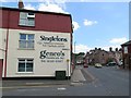
Genco's Sandwich Bar, Carlisle
On Newtown Road.
Image: © JThomas
Taken: 28 May 2016
0.08 miles