IMAGES TAKEN NEAR TO
Monks Hill, ST. BEES, CA27 0EQ
Introduction
This page details the photographs taken nearby to Monks Hill, CA27 0EQ by members of the Geograph project.
The Geograph project started in 2005 with the aim of publishing, organising and preserving representative images for every square kilometre of Great Britain, Ireland and the Isle of Man.

There are currently over 7.5m images from over14,400 individuals and you can help contribute to the project by visiting https://www.geograph.org.uk
Image Map
Images are licensed for reuse under creativecommons.org/licenses/by-sa/2.0
Notes
- Clicking on the map will re-center to the selected point.
- The higher the marker number, the further away the image location is from the centre of the postcode.
Image Listing (48 Images Found)
Images are licensed for reuse under creativecommons.org/licenses/by-sa/2.0
Image
Details
Distance
1

Abbott's Court House
Part of St Bees School
Image: © N Chadwick
Taken: 29 May 2009
0.05 miles
3

Abbott's Court House
Part of St Bees school.
Image: © N Chadwick
Taken: 29 May 2009
0.08 miles
5

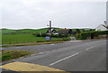
No new housing here!
This is on Abbey Road. The abbey is off to the left. There is currently an open view over to the centre of St Bees on the opposite hillside.
Image: © Bill Boaden
Taken: 19 Jul 2010
0.09 miles

10
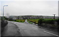
The junction of Station Road with Abbey Road
Apologies for the raindrop distortion!
Image: © Bill Boaden
Taken: 19 Jul 2010
0.14 miles