IMAGES TAKEN NEAR TO
High House Road, ST. BEES, CA27 0BZ
Introduction
This page details the photographs taken nearby to High House Road, CA27 0BZ by members of the Geograph project.
The Geograph project started in 2005 with the aim of publishing, organising and preserving representative images for every square kilometre of Great Britain, Ireland and the Isle of Man.

There are currently over 7.5m images from over14,400 individuals and you can help contribute to the project by visiting https://www.geograph.org.uk
Image Map
Images are licensed for reuse under creativecommons.org/licenses/by-sa/2.0
Notes
- Clicking on the map will re-center to the selected point.
- The higher the marker number, the further away the image location is from the centre of the postcode.
Image Listing (4 Images Found)
Images are licensed for reuse under creativecommons.org/licenses/by-sa/2.0
Image
Details
Distance
1
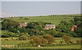
Three large houses on High House Road
From left to right these are Meadow Bank, Fern Bank & The Knoll
Image: © N Chadwick
Taken: 29 May 2009
0.03 miles
2
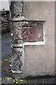
Benchmark at Grindell Place, Finkle Street
Ordnance Survey cut mark benchmark described on the Bench Mark Database at http://www.bench-marks.org.uk/bm43695
Image: © Roger Templeman
Taken: 21 Jun 2012
0.24 miles
3
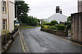
Finkle Street on a damp day
There is an OS benchmark Image in a cutout in the mock stone wall on the right hand side of the image. The house on the left is for sale.
Image: © Roger Templeman
Taken: 21 Jun 2012
0.24 miles
4
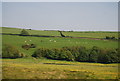
Looking east across the valley of Pow Beck
Image: © N Chadwick
Taken: 29 May 2009
0.24 miles