IMAGES TAKEN NEAR TO
Blythe Place, Sea Mill Lane, ST. BEES, CA27 0BE
Introduction
This page details the photographs taken nearby to Blythe Place, Sea Mill Lane, CA27 0BE by members of the Geograph project.
The Geograph project started in 2005 with the aim of publishing, organising and preserving representative images for every square kilometre of Great Britain, Ireland and the Isle of Man.

There are currently over 7.5m images from over14,400 individuals and you can help contribute to the project by visiting https://www.geograph.org.uk
Image Map
Images are licensed for reuse under creativecommons.org/licenses/by-sa/2.0
Notes
- Clicking on the map will re-center to the selected point.
- The higher the marker number, the further away the image location is from the centre of the postcode.
Image Listing (23 Images Found)
Images are licensed for reuse under creativecommons.org/licenses/by-sa/2.0
Image
Details
Distance
2
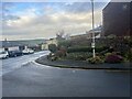
St Bees Flowerbed at entrance to Village
Village top bus turning circle with St Bees garden
Image: © Karen Kelso
Taken: 1 Jan 1970
0.05 miles
3
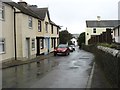
Approaching St Bees from the south
On the B5345.
Image: © David Purchase
Taken: 4 Oct 2017
0.10 miles