IMAGES TAKEN NEAR TO
Outrigg, ST. BEES, CA27 0AN
Introduction
This page details the photographs taken nearby to Outrigg, CA27 0AN by members of the Geograph project.
The Geograph project started in 2005 with the aim of publishing, organising and preserving representative images for every square kilometre of Great Britain, Ireland and the Isle of Man.

There are currently over 7.5m images from over14,400 individuals and you can help contribute to the project by visiting https://www.geograph.org.uk
Image Map
Images are licensed for reuse under creativecommons.org/licenses/by-sa/2.0
Notes
- Clicking on the map will re-center to the selected point.
- The higher the marker number, the further away the image location is from the centre of the postcode.
Image Listing (18 Images Found)
Images are licensed for reuse under creativecommons.org/licenses/by-sa/2.0
Image
Details
Distance
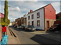
4
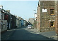
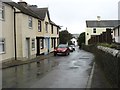
Egremont Road, St Bees
A damp grey day blends well with this northern town view.
Image: © Bill Boaden
Taken: 19 Jul 2010
0.13 miles
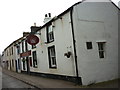
6
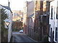
Town Centre St Bees.
The Liberal club is on the right in this congested part of town.
Image: © John Holmes
Taken: 11 Dec 2005
0.14 miles
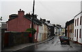
7
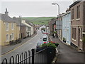
Main Street St Bees
A typical view of the Villages main street, conveniently named Main Street
Image: © Perry Dark
Taken: 1 Jul 2012
0.15 miles
9
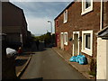
Approaching St Bees from the south
On the B5345.
Image: © David Purchase
Taken: 4 Oct 2017
0.17 miles
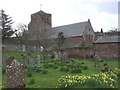
10
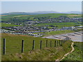
St Bees And The Cumbrian Fells
As viewed from the coastal path on South Head.
Image: © James T M Towill
Taken: 27 May 2012
0.18 miles