IMAGES TAKEN NEAR TO
St. Edmunds Park, CARLISLE, CA2 6TS
Introduction
This page details the photographs taken nearby to St. Edmunds Park, CA2 6TS by members of the Geograph project.
The Geograph project started in 2005 with the aim of publishing, organising and preserving representative images for every square kilometre of Great Britain, Ireland and the Isle of Man.

There are currently over 7.5m images from over14,400 individuals and you can help contribute to the project by visiting https://www.geograph.org.uk
Image Map
Images are licensed for reuse under creativecommons.org/licenses/by-sa/2.0
Notes
- Clicking on the map will re-center to the selected point.
- The higher the marker number, the further away the image location is from the centre of the postcode.
Image Listing (29 Images Found)
Images are licensed for reuse under creativecommons.org/licenses/by-sa/2.0
Image
Details
Distance
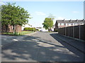
6
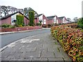
Bungalows on Holmrook Road, Carlisle
Currently the last street of houses on Carlisle's south-western edge.
Image: © Christine Johnstone
Taken: 2 Nov 2015
0.08 miles


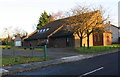
9
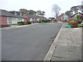
Holmrook Road, Carlisle
All the cul-de-sacs off Holmrook Road are also called Holmrook Road. The 50 metre contour runs across the bend in the road.
Image: © Christine Johnstone
Taken: 2 Nov 2015
0.09 miles
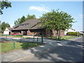
10
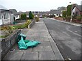
Bin day, Holmrook Road, Carlisle
On this particular Monday, recycling boxes and bags were being emptied.
Image: © Christine Johnstone
Taken: 2 Nov 2015
0.10 miles