IMAGES TAKEN NEAR TO
Little Orton Road, CARLISLE, CA2 6RB
Introduction
This page details the photographs taken nearby to Little Orton Road, CA2 6RB by members of the Geograph project.
The Geograph project started in 2005 with the aim of publishing, organising and preserving representative images for every square kilometre of Great Britain, Ireland and the Isle of Man.

There are currently over 7.5m images from over14,400 individuals and you can help contribute to the project by visiting https://www.geograph.org.uk
Image Map
Images are licensed for reuse under creativecommons.org/licenses/by-sa/2.0
Notes
- Clicking on the map will re-center to the selected point.
- The higher the marker number, the further away the image location is from the centre of the postcode.
Image Listing (8 Images Found)
Images are licensed for reuse under creativecommons.org/licenses/by-sa/2.0
Image
Details
Distance
1
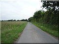
Minor road towards Little Orton
Heading north west.
Image: © JThomas
Taken: 18 Jun 2016
0.07 miles
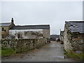
3
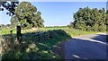
Gateway at bend in road NW of Bunkershill
Image: © Roger Templeman
Taken: 4 Sep 2023
0.19 miles
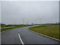
4
A689 approaching Orton Road Roundabout
Heading north west.
Image: © JThomas
Taken: 18 Jun 2016
0.21 miles
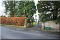
5
East End, Bunkershill on northwest side of Orton Road
Image: © Luke Shaw
Taken: 4 Sep 2023
0.22 miles
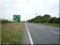
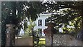
7
Entrance to East End, Bunkershill
There is an OS benchmark Image on the right hand gatepost
Image: © Luke Shaw
Taken: 3 Dec 2019
0.23 miles
8
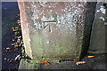
Benchmark on stone gatepost at entrance to East End, Bunkershill
Ordnance Survey cut mark benchmark described on the Bench Mark Database at https://www.bench-marks.org.uk/bm78085
Image: © Luke Shaw
Taken: 3 Dec 2019
0.23 miles