IMAGES TAKEN NEAR TO
Newlaithes Avenue, CARLISLE, CA2 6PW
Introduction
This page details the photographs taken nearby to Newlaithes Avenue, CA2 6PW by members of the Geograph project.
The Geograph project started in 2005 with the aim of publishing, organising and preserving representative images for every square kilometre of Great Britain, Ireland and the Isle of Man.

There are currently over 7.5m images from over14,400 individuals and you can help contribute to the project by visiting https://www.geograph.org.uk
Image Map
Images are licensed for reuse under creativecommons.org/licenses/by-sa/2.0
Notes
- Clicking on the map will re-center to the selected point.
- The higher the marker number, the further away the image location is from the centre of the postcode.
Image Listing (18 Images Found)
Images are licensed for reuse under creativecommons.org/licenses/by-sa/2.0
Image
Details
Distance
1
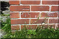
Benchmark on #89 Westrigg Road
Ordnance Survey cur mark benchmark described on the Bench Mark Database at http://www.bench-marks.org.uk/bm68840
Image: © Roger Templeman
Taken: 7 Jul 2015
0.02 miles
2
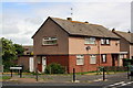
Houses at Westrigg Road / Newlaithes Avenue junction
There is an OS benchmark Image on the near corner of the houses, right hand face
Image: © Roger Templeman
Taken: 7 Jul 2015
0.02 miles
3
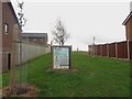
Young trees, Westrigg Road, Carlisle
A gap between houses on Westrigg Road is the location for a handful of trees which, according to the large poster, have been planted as part of the government led "The Big Tree Plant scheme". The scheme aimed to encourage communities throughout England to plant one million new trees around urban areas and communities and was scheduled to run from 2010 to 2015.
Image: © Graham Robson
Taken: 30 Oct 2014
0.08 miles
4
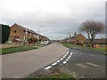
Levens Drive, Carlisle
Looking along Levens Drive, a residential street in the Morton area of Carlisle.
Image: © Graham Robson
Taken: 30 Oct 2014
0.11 miles
5
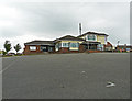
The Border Terrier, Morton
Pub in Ashness Drive with a big car park, viewed from Newlaithes Avenue. Opened in 1967, closed July 2014, demolished May 2015. Houses will be built on the site
Image: © Rose and Trev Clough
Taken: 8 Aug 2014
0.15 miles
6
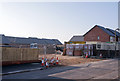
Site of "The Border Terrier" - January 2017 (1)
Opened by the State Management Scheme in 1967, "The Border Terrier" was sold to Scottish & Newcastle Breweries in April 1973. A nondescript 1960's building, the pub closed in 2014 and was later demolished. The site is currently being developed for private housing.
Rose & Trev Clough were there in 2014 and their photograph can be seen: Image] .
Image: © The Carlisle Kid
Taken: 26 Jan 2017
0.16 miles
7
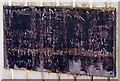
Site of "The Border Terrier" - January 2017 (2)
All that remains of "The Border Terrier" pub - a faded sign advertising "Home Made Bar Meals".
Image: © The Carlisle Kid
Taken: 26 Jan 2017
0.16 miles
8
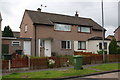
Semi-detached houses on Newlaithes Avenue
Image: © Roger Templeman
Taken: 7 Jul 2015
0.17 miles
9
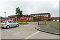
Newlaithes Infant School
This school in Langrigg Road, Morton, opened in 1965 and caters for pupils aged 3 to 7. It is next door to Image .
Newlaithes is one of three infant schools in Carlisle, there used to be others but over the years they have been amalgamated with nearby junior schools to create all-through primaries for ages 3 to 11.
Image: © Rose and Trev Clough
Taken: 8 Aug 2014
0.21 miles
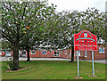
10
Newlaithes Junior School
This school in Langrigg Road, Morton, opened in 1963 and caters for pupils aged 7 to 11.
It is next door to Image .
Image: © Rose and Trev Clough
Taken: 8 Aug 2014
0.23 miles