IMAGES TAKEN NEAR TO
Wigton Road, CARLISLE, CA2 6JR
Introduction
This page details the photographs taken nearby to Wigton Road, CA2 6JR by members of the Geograph project.
The Geograph project started in 2005 with the aim of publishing, organising and preserving representative images for every square kilometre of Great Britain, Ireland and the Isle of Man.

There are currently over 7.5m images from over14,400 individuals and you can help contribute to the project by visiting https://www.geograph.org.uk
Image Map
Images are licensed for reuse under creativecommons.org/licenses/by-sa/2.0
Notes
- Clicking on the map will re-center to the selected point.
- The higher the marker number, the further away the image location is from the centre of the postcode.
Image Listing (42 Images Found)
Images are licensed for reuse under creativecommons.org/licenses/by-sa/2.0
Image
Details
Distance
1
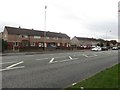
Terraced houses on Wigton Road
Short rows of fairly nondescript terraced houses facing onto Wigton Road in the Morton area of Carlisle.
Image: © Graham Robson
Taken: 30 Oct 2014
0.01 miles
2
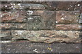
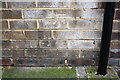
Benchmark on Morton Bridge, Wigton Road
Ordnance Survey cut mark benchmark described on the Bench Mark Database at http://www.bench-marks.org.uk/bm68839
Image: © Roger Templeman
Taken: 7 Jul 2015
0.07 miles
3
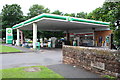
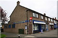
Bridge parapet, BP petrol station and Spar shop, Wigton Road
There is an OS benchmark Image on the bridge parapet left of the stone inscribed 'Morton Bridge Widened 1936'.
Image: © Roger Templeman
Taken: 7 Jul 2015
0.08 miles
4
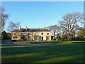
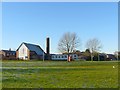
Morton Manor
An early 19th century building, which has been used as the Morton Community Centre since 1967. The house and surrounding park were given to the people of Carlisle by Sir Robert Chance, whose family lived there for many years. He was an industrialist and prominent citizen who died in 1960. In front of the house is a ha-ha, a ditch built to keep grazing animals out of the garden.
Image: © Rose and Trev Clough
Taken: 3 Dec 2008
0.08 miles
5
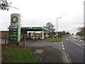
Fuel filling station, Wigton Road, Carlisle
A BP fuel filling station on Wigton Road. The garage sits on the side of the main road used by traffic approaching from the south west of the city.
Image: © Graham Robson
Taken: 30 Oct 2014
0.09 miles
6
Saint Luke's Church, Morton
Church of England, on Stonegarth, consecrated in 1960.
Image: © Rose and Trev Clough
Taken: 3 Dec 2008
0.12 miles
7
Notman's Newsagents, #23 Stonegarth
There is an OS benchmark Image on the side of the shop, left of the black downpipe
Image: © Roger Templeman
Taken: 7 Jul 2015
0.16 miles
8
Benchmark on #23 Stonegarth
Ordnance Survey cut mark benchmark described on the Bench Mark Database at http://www.bench-marks.org.uk/bm68838
Image: © Roger Templeman
Taken: 7 Jul 2015
0.16 miles
9
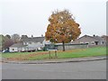
Autumn tree, Crosshill Drive, Morton, Carlisle
At the junction with Queensway.
Image: © Christine Johnstone
Taken: 2 Nov 2015
0.16 miles
10
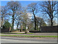
Morton Park entrance, Carlisle
On Wigton Road [A595].
Image: © M J Richardson
Taken: 18 Apr 2023
0.17 miles