IMAGES TAKEN NEAR TO
Inglewood Road, CARLISLE, CA2 6JH
Introduction
This page details the photographs taken nearby to Inglewood Road, CA2 6JH by members of the Geograph project.
The Geograph project started in 2005 with the aim of publishing, organising and preserving representative images for every square kilometre of Great Britain, Ireland and the Isle of Man.

There are currently over 7.5m images from over14,400 individuals and you can help contribute to the project by visiting https://www.geograph.org.uk
Image Map
Images are licensed for reuse under creativecommons.org/licenses/by-sa/2.0
Notes
- Clicking on the map will re-center to the selected point.
- The higher the marker number, the further away the image location is from the centre of the postcode.
Image Listing (38 Images Found)
Images are licensed for reuse under creativecommons.org/licenses/by-sa/2.0
Image
Details
Distance
1
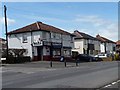
Bells Newsagents, Orton Road, Carlisle
At the corner of Inglewood Road.
Image: © Christine Johnstone
Taken: 11 Apr 2014
0.03 miles
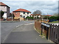
2
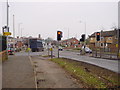
Road Junction
The minor road from the Raffles Estate and new housing areas meet the A595. Looking north-east towards Carlisle centre.
Image: © Bob Jenkins
Taken: 6 Feb 2006
0.04 miles
4
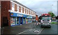
Nos. 48 and 46 Orton Road, next to Raffles electricity substation
There is an OS benchmark Image on the side of the left hand house near its front corner
Image: © Luke Shaw
Taken: 3 Dec 2019
0.04 miles
5
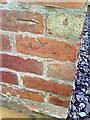
Benchmark on #48 Orton Road
Ordnance Survey cut mark benchmark on the side of the house. The mark is described in detail on the Bench Mark Database at http://www.bench-marks.org.uk/bm34903.
Image: © Roger Templeman
Taken: 17 Jul 2010
0.04 miles
6
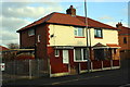
Dalton Avenue, Carlisle
Running north from Orton Road.
Image: © Christine Johnstone
Taken: 11 Apr 2014
0.05 miles
7
Horse & Farrier, Wigtown Road, Carlisle - January 2017 (2)
For information on this building, see: Image] .
Image: © The Carlisle Kid
Taken: 5 Jan 2017
0.06 miles
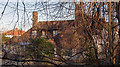
8
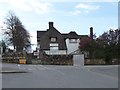
Horse & Farrier, Wigtown Road, Carlisle - January 2017 (1)
Designed by Harry Redfern to replace an existing Horse & Farrier pub on the opposite side of the Wigtown Road, the new pub opened on 16 September 1929 to serve an expanding housing estate. Released from State ownership in 1973, the pub closed in 2007 and has been unoccupied since - despite the best efforts of Carlisle Council to find new owners. Although Grade II listed, the building's future is uncertain. See also: Image] and Image] .
For a view of the building without the security fencing, see: http://www.closedpubs.co.uk/cumberland/carlisle_horsefarrier.html
Image: © The Carlisle Kid
Taken: 5 Jan 2017
0.06 miles
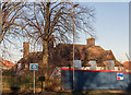
9
Boarded-up pub, Wigton Road, Carlisle
At the junction with Orton Road.
Image: © Christine Johnstone
Taken: 11 Apr 2014
0.06 miles
10
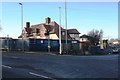
Horse and Farrier pub boarded up at Wigton Road / Orton Road junction junction
There is/was a wall with a benchmark Image behind the boarding - I wonder if it is still there - the pub certainly is and being renovated.
Image: © Luke Shaw
Taken: 3 Jan 2020
0.07 miles