IMAGES TAKEN NEAR TO
Kentmere Grove, CARLISLE, CA2 6JD
Introduction
This page details the photographs taken nearby to Kentmere Grove, CA2 6JD by members of the Geograph project.
The Geograph project started in 2005 with the aim of publishing, organising and preserving representative images for every square kilometre of Great Britain, Ireland and the Isle of Man.

There are currently over 7.5m images from over14,400 individuals and you can help contribute to the project by visiting https://www.geograph.org.uk
Image Map
Images are licensed for reuse under creativecommons.org/licenses/by-sa/2.0
Notes
- Clicking on the map will re-center to the selected point.
- The higher the marker number, the further away the image location is from the centre of the postcode.
Image Listing (24 Images Found)
Images are licensed for reuse under creativecommons.org/licenses/by-sa/2.0
Image
Details
Distance
1
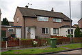
Semi-detached houses on Newlaithes Avenue
Image: © Roger Templeman
Taken: 7 Jul 2015
0.07 miles
2
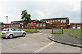
Newlaithes Junior School
This school in Langrigg Road, Morton, opened in 1963 and caters for pupils aged 7 to 11.
It is next door to Image .
Image: © Rose and Trev Clough
Taken: 8 Aug 2014
0.13 miles
3
Church of Jesus Christ of Latter-Day Saints at Langrigg Road / Park Road junction
There is an OS benchmark Image on top of the wall at the entrance to the church
Image: © Roger Templeman
Taken: 7 Jul 2015
0.13 miles
4
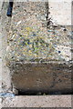
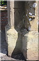
Benchmark on wall at entrance to Latter Day Saints Church
Ordnance Survey rivet benchmark described on the Bench Mark Database at http://www.bench-marks.org.uk/bm68711
Image: © Roger Templeman
Taken: 7 Jul 2015
0.13 miles
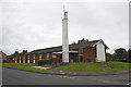
5
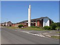
Church of Jesus Christ of Latter Day Saints, Carlisle
Striking modern church on Langrigg Road
Image: © Oliver Dixon
Taken: 18 Jul 2006
0.14 miles
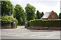
6
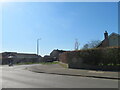
Woodend Drive, Carlisle
A turning off Dalston Road into an housing estate at Longsowerby.
Image: © M J Richardson
Taken: 18 Apr 2023
0.16 miles
7
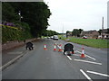
Roadworks on Dalston Road (B5299)
Looking south west.
Image: © JThomas
Taken: 18 Jun 2016
0.16 miles
8
Benchmark on gatepost at entrance to crematorium
Ordnance Survey cut mark benchmark described on the Bench Mark Database at http://www.bench-marks.org.uk/bm68841
Image: © Roger Templeman
Taken: 7 Jul 2015
0.17 miles
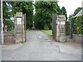
10
Dalston Road entrance to crematorium
There is an OS benchmark Image on the inside face of the left hand gatepost
Image: © Roger Templeman
Taken: 7 Jul 2015
0.17 miles