IMAGES TAKEN NEAR TO
Rashdall Road, CARLISLE, CA2 6HR
Introduction
This page details the photographs taken nearby to Rashdall Road, CA2 6HR by members of the Geograph project.
The Geograph project started in 2005 with the aim of publishing, organising and preserving representative images for every square kilometre of Great Britain, Ireland and the Isle of Man.

There are currently over 7.5m images from over14,400 individuals and you can help contribute to the project by visiting https://www.geograph.org.uk
Image Map
Images are licensed for reuse under creativecommons.org/licenses/by-sa/2.0
Notes
- Clicking on the map will re-center to the selected point.
- The higher the marker number, the further away the image location is from the centre of the postcode.
Image Listing (26 Images Found)
Images are licensed for reuse under creativecommons.org/licenses/by-sa/2.0
Image
Details
Distance
1
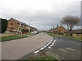
Levens Drive, Carlisle
Looking along Levens Drive, a residential street in the Morton area of Carlisle.
Image: © Graham Robson
Taken: 30 Oct 2014
0.09 miles
2
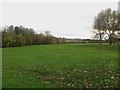
Playing field between houses and Dalston Road
A grass playing field occupying an area of grass between the Morton residential area and Dalston Road.
Image: © Graham Robson
Taken: 30 Oct 2014
0.11 miles
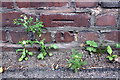
4
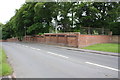
Cemetery wall beside B5299
There is an OS benchmark Image on the wall pier left of the corner pier
Image: © Roger Templeman
Taken: 7 Jul 2015
0.14 miles
5
Benchmark on Dalston Road crematorium wall
Ordnance Survey cut mark benchmark described on the Bench Mark Database at http://www.bench-marks.org.uk/bm68842
Image: © Roger Templeman
Taken: 7 Jul 2015
0.14 miles
6
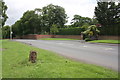
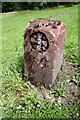
B5299 at Carlisle Crematorium
Image is a closeup of the boundary stone located on the left hand verge of the road
Image: © Roger Templeman
Taken: 7 Jul 2015
0.14 miles
7
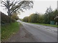
Dalston Road, Carlisle
Looking south along Dalston Road.
Image: © Graham Robson
Taken: 30 Oct 2014
0.14 miles
8
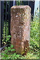
Benchmark on post beside track off Dalston Road
Ordnance Survey cut mark benchmark described on the Bench Mark Database at http://www.bench-marks.org.uk/bm68834
Image: © Roger Templeman
Taken: 7 Jul 2015
0.15 miles
9
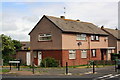
Houses at Westrigg Road / Newlaithes Avenue junction
There is an OS benchmark Image on the near corner of the houses, right hand face
Image: © Roger Templeman
Taken: 7 Jul 2015
0.15 miles
10
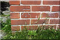
Benchmark on #89 Westrigg Road
Ordnance Survey cur mark benchmark described on the Bench Mark Database at http://www.bench-marks.org.uk/bm68840
Image: © Roger Templeman
Taken: 7 Jul 2015
0.15 miles