IMAGES TAKEN NEAR TO
Ferguson Place, CARLISLE, CA2 6EF
Introduction
This page details the photographs taken nearby to Ferguson Place, CA2 6EF by members of the Geograph project.
The Geograph project started in 2005 with the aim of publishing, organising and preserving representative images for every square kilometre of Great Britain, Ireland and the Isle of Man.

There are currently over 7.5m images from over14,400 individuals and you can help contribute to the project by visiting https://www.geograph.org.uk
Image Map (Loading...)


Getting Data...Please wait
Leaflet Map data © OpenStreetMap
Images are licensed for reuse under creativecommons.org/licenses/by-sa/2.0
Notes
- Clicking on the map will re-center to the selected point.
- The higher the marker number, the further away the image location is from the centre of the postcode.
Image Listing (62 Images Found)
Images are licensed for reuse under creativecommons.org/licenses/by-sa/2.0
Image
Details
Distance
1

Allotments behind Richardson Street
Image: © Rose and Trev Clough
Taken: 26 Aug 2016
0.04 miles
2

Houses on Richardson Street, #38 next to #48
There is an OS benchmark Image on the left hand house of the pair about 1 foot left of their junction
Image: © Roger Templeman
Taken: 7 Jul 2015
0.11 miles
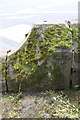
3

Benchmark on #48 Richardson Street
Ordnance Survey cut mark benchmark described on the Bench Mark Database at http://www.bench-marks.org.uk/bm68951
Image: © Roger Templeman
Taken: 7 Jul 2015
0.11 miles

5

Wall of St James' Church's grounds boundary at crossroads
There is an OS benchmark Image on the wall on the stone with the upward curve.
Image: © Roger Templeman
Taken: 7 Jul 2015
0.13 miles
6
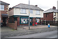
Jaspers Convenience Store
A general store and off-licence in Waldegrave Road, Longsowerby.
Image: © Rose and Trev Clough
Taken: 30 Mar 2016
0.13 miles
7

Benchmark on Holme View House wall, Norfolk Road
Ordnance Survey pivot benchmark described on the Bench Mark Database at http://www.bench-marks.org.uk/bm39016
Image: © Roger Templeman
Taken: 7 Aug 2011
0.15 miles
8

Houses at the east end of Norfolk Road
There is an OS benchmark Image on top of the wall above the blue book on the pavement
Image: © Roger Templeman
Taken: 7 Jul 2015
0.15 miles
9
Benchmark on back of wall at St James' Road / Norfolk Street junction
Ordnance Survey cut mark benchmark described on the Bench Mark Database at http://www.bench-marks.org.uk/bm68946
Image: © Roger Templeman
Taken: 7 Jul 2015
0.15 miles
10
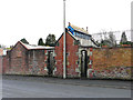
Disused public toilets, Richardson Street
In the wall surrounding Carlisle Cemetery. Other toilets are available inside the grounds.
Image: © Rose and Trev Clough
Taken: 14 Feb 2019
0.15 miles