IMAGES TAKEN NEAR TO
Gilbert Road, CARLISLE, CA2 6BJ
Introduction
This page details the photographs taken nearby to Gilbert Road, CA2 6BJ by members of the Geograph project.
The Geograph project started in 2005 with the aim of publishing, organising and preserving representative images for every square kilometre of Great Britain, Ireland and the Isle of Man.

There are currently over 7.5m images from over14,400 individuals and you can help contribute to the project by visiting https://www.geograph.org.uk
Image Map (Loading...)


Getting Data...Please wait
Leaflet Map data © OpenStreetMap
Images are licensed for reuse under creativecommons.org/licenses/by-sa/2.0
Notes
- Clicking on the map will re-center to the selected point.
- The higher the marker number, the further away the image location is from the centre of the postcode.
Image Listing (15 Images Found)
Images are licensed for reuse under creativecommons.org/licenses/by-sa/2.0
Image
Details
Distance
1
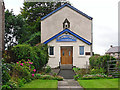
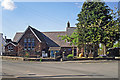
St James Church, Cummersdale
This is a daughter church to St James, Denton Holme. Services are held every sunday morning.
The building was originally part of a bacon curing factory http://www.cummersdalehistory.co.uk/high-cummersdale.html (as is the village hall http://www.geograph.org.uk/photo/5126426 ).
Image: © Rose and Trev Clough
Taken: 13 Aug 2016
0.08 miles
2
The Embassy Ballroom/Village Hall, Cummersdale
The building dates from 1893, it was originally part of a bacon curing factory. In 1924 it was bought by EW Stead of Stead McAlpin cloth printers and given in trust to the community to be used as a village hall, billiard room, concert room, reading room and recreation room (information from Parish Council http://cummersdaleparishcouncil.org.uk/wp-content/uploads/Cummersdale-VH-Case-study.pdf ).
Image: © Rose and Trev Clough
Taken: 13 Aug 2016
0.08 miles
3
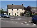
Village centre, Cummersdale
Hidden away at the end of a cul de sac off the Dalston Road, Carlisle. There are few facilities beyond a bus stop and a pub just down the road.
Image: © Oliver Dixon
Taken: 18 Jul 2006
0.09 miles
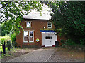
4

Farm in Cummersdale
Set right in the middle of the village
Image: © Oliver Dixon
Taken: 18 Jul 2006
0.09 miles
7
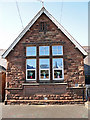
Date stone at Cummersdale School
It says 'Cummersdale Board School A.D. 1884'.
Image: © Rose and Trev Clough
Taken: 2 May 2014
0.11 miles
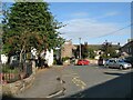
8
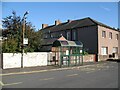
Bus stop, Cummersdale
In the square in the centre of Cummersdale, this bus stop is served by the number 75 service from Bridge End to Cotehill, operated by Reay's.
Image: © Adrian Taylor
Taken: 27 Sep 2013
0.12 miles
9

The Spinners Arms, Cummersdale
A village pub built in 1930 under the Carlisle State Management Scheme (government control of alcohol in the area from 1916 to 1973). The architect was Harry Redfern, who designed several pubs for the scheme in a variety of styles. More historical information is available on the Spinners website http://www.thespinnersarms.org.uk/History.html .
The Spinners Arms is a listed building - for architectural details (and a photo taken 2002 when it was painted less pleasingly in brown) see Images of England http://www.imagesofengland.org.uk/Details/Default.aspx?id=77581 .
The pub has several charming design features, for example see Image .
Image: © Rose and Trev Clough
Taken: 13 Aug 2016
0.12 miles
10
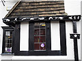
Decorative guttering at the Spinners Arms
Goodness knows where the inspiration for these animal characters came from.
Full view of the pub here Image .
Image: © Rose and Trev Clough
Taken: 13 Aug 2016
0.12 miles