IMAGES TAKEN NEAR TO
Rowrah, FRIZINGTON, CA26 3XS
Introduction
This page details the photographs taken nearby to CA26 3XS by members of the Geograph project.
The Geograph project started in 2005 with the aim of publishing, organising and preserving representative images for every square kilometre of Great Britain, Ireland and the Isle of Man.

There are currently over 7.5m images from over14,400 individuals and you can help contribute to the project by visiting https://www.geograph.org.uk
Image Map
Images are licensed for reuse under creativecommons.org/licenses/by-sa/2.0
Notes
- Clicking on the map will re-center to the selected point.
- The higher the marker number, the further away the image location is from the centre of the postcode.
Image Listing (2 Images Found)
Images are licensed for reuse under creativecommons.org/licenses/by-sa/2.0
Image
Details
Distance
1
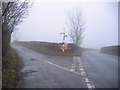
Turnoff for Karting Rowrah.
An international karting track in a disused quarry lies on the left of here.
Image: © John Holmes
Taken: 10 Dec 2005
0.21 miles
2
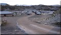
The Karting pits area Rowrah.
You need to be good at mountains to identify those in the background, the sun is not warming this Karting quarry at all and is currently minus 3 degrees according to my vehicle instruments.
Image: © John Holmes
Taken: 29 Dec 2005
0.23 miles