IMAGES TAKEN NEAR TO
Winder, FRIZINGTON, CA26 3UL
Introduction
This page details the photographs taken nearby to CA26 3UL by members of the Geograph project.
The Geograph project started in 2005 with the aim of publishing, organising and preserving representative images for every square kilometre of Great Britain, Ireland and the Isle of Man.

There are currently over 7.5m images from over14,400 individuals and you can help contribute to the project by visiting https://www.geograph.org.uk
Image Map
Images are licensed for reuse under creativecommons.org/licenses/by-sa/2.0
Notes
- Clicking on the map will re-center to the selected point.
- The higher the marker number, the further away the image location is from the centre of the postcode.
Image Listing (2 Images Found)
Images are licensed for reuse under creativecommons.org/licenses/by-sa/2.0
Image
Details
Distance
1
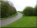
The road to Eskett Quarries
This private road was built, I think about 15 years ago, to relieve the village of Winder from heavy quarry traffic.
Image: © David Purchase
Taken: 1 May 2014
0.04 miles
2
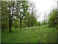
Woodland near Winder
Pleasant country on the footpath to Rowrah. If, of course, you can ignore the activity in the quarry behind you!
Image: © David Purchase
Taken: 1 May 2014
0.08 miles