IMAGES TAKEN NEAR TO
Wetheral Street, CARLISLE, CA2 5UP
Introduction
This page details the photographs taken nearby to Wetheral Street, CA2 5UP by members of the Geograph project.
The Geograph project started in 2005 with the aim of publishing, organising and preserving representative images for every square kilometre of Great Britain, Ireland and the Isle of Man.

There are currently over 7.5m images from over14,400 individuals and you can help contribute to the project by visiting https://www.geograph.org.uk
Image Map
Images are licensed for reuse under creativecommons.org/licenses/by-sa/2.0
Notes
- Clicking on the map will re-center to the selected point.
- The higher the marker number, the further away the image location is from the centre of the postcode.
Image Listing (142 Images Found)
Images are licensed for reuse under creativecommons.org/licenses/by-sa/2.0
Image
Details
Distance
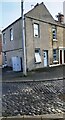
1
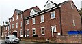
St Bedes Terrace on SW side of Silloth Street
Previously the site of a club on which Ordnance Survey records indicate a benchmark was levelled at 15.934m above Newlyn Datum in 1972.
Image: © Roger Templeman
Taken: 9 Oct 2021
0.03 miles
2
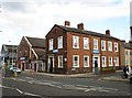
West End Temperance Hall
At the corner of Church Street and Hawick Street. The hall was erected in 1861 (date stone below roof), it also contained a working men's reading room. It is currently used for meetings, e.g. by the Carlisle Christian Spiritualist Church. A dance studio is due to open here soon.
Further left is Scotby Cycles, occupying what was originally the Caldewgate Wesleyan Chapel (built 1865), which later became the Regal Cinema.
Between these two buildings is the small shop front of an electrical appliance repair business.
Image: © Rose and Trev Clough
Taken: 8 Sep 2011
0.04 miles
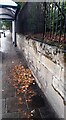
3
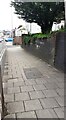
Looking NE along Wigton Road at the site of bridge of dismantled railway
There is an Ordnance Survey benchmark on the second stone above the pavement on the near corner of the bridge wall
Image: © Roger Templeman
Taken: 12 Jul 2021
0.04 miles
4
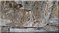
Benchmark? on wall on NW side of Wigton Road
It looks like an Ordnance Survey cut mark benchmark but there is no reference to it in OS records, nor is it shown on Old Maps
Image: © Roger Templeman
Taken: 2 Oct 2021
0.05 miles
5
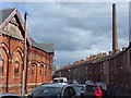
Morton Street and Dixon's Chimney, Carlisle
Image: © Andrew Smith
Taken: 19 Jun 2008
0.05 miles
6
Morton Street and Dixon's Chimney, Carlisle
Image: © Andrew Smith
Taken: 19 Jun 2008
0.05 miles
7
Closed toilet and former railway line, Wigton Road
The gents toilet was demolished in 2013 (closer view here Image ).
The lane on the left, behind Silloth Street, follows the line of a former railway which closed in 1969. This was originally the Canal Branch of the Newcastle and Carlisle Railway (opened 1837, from London Road Station to Carlisle Canal Basin).
Image: © Rose and Trev Clough
Taken: 8 Sep 2011
0.06 miles
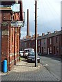
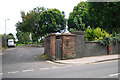
8

Disused public convenience, Wigton Road
Gents toilet, demolished in 2013.
For view of location, see Image .
Image: © Rose and Trev Clough
Taken: 9 Oct 2011
0.06 miles
9
#15 York Street at Kendal Street junction
Ordnance Survey records indicate that a benchmark was levelled at 15.758m above Newlyn Datum in 1972 on the near corner, right hand face, of the house. The house is now covered with pebbledash.
Image: © Roger Templeman
Taken: 22 Dec 2020
0.06 miles
10
Wall and bus shelter on NW side of Wigton Road opposite Silloth Street
There is what appears to be an Ordnance Survey benchmark Image on the wall's third stone above the pavement near the right edge of the image
Image: © Roger Templeman
Taken: 2 Oct 2021
0.06 miles