IMAGES TAKEN NEAR TO
Willow Holme Road, CARLISLE, CA2 5SQ
Introduction
This page details the photographs taken nearby to Willow Holme Road, CA2 5SQ by members of the Geograph project.
The Geograph project started in 2005 with the aim of publishing, organising and preserving representative images for every square kilometre of Great Britain, Ireland and the Isle of Man.

There are currently over 7.5m images from over14,400 individuals and you can help contribute to the project by visiting https://www.geograph.org.uk
Image Map
Images are licensed for reuse under creativecommons.org/licenses/by-sa/2.0
Notes
- Clicking on the map will re-center to the selected point.
- The higher the marker number, the further away the image location is from the centre of the postcode.
Image Listing (479 Images Found)
Images are licensed for reuse under creativecommons.org/licenses/by-sa/2.0
Image
Details
Distance
1
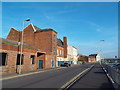
Willow Holme Road, Carlisle
Willow Holme Road in Carlisle.
Image: © Malc McDonald
Taken: 23 Apr 2015
0.02 miles
2
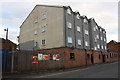
Former GPO building, Willow Holme Road
Now apartments above car park
Image: © Roger Templeman
Taken: 16 Aug 2019
0.03 miles
3
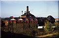
Theakston Carlisle Brewery
That's what it said on the water tank. I wonder what it is now?
Image: © Chris Allen
Taken: 3 Nov 1986
0.04 miles
4
Site of "Graham's Queens Brewery" - December 2016
Opened in 1860 and also sometimes known as Queen's Brewery (Graham's), the brewery was fronted by the Queens Head Inn and the Royal Oak Inn (approximately where I am standing). The brewery came under State control in September 1916 and was almost immediately closed, the buildings being demolished in 1928/29. The Queens Head was closed in 1918, while the Royal Oak became an off-licence by 1920 and was demolished in 1987. It is not clear what use was made of the brewery site in the years between 1929 and the construction of Sainsbury's circa 2005.
Sainsbury's wine and spirit shelves are situated on the approximate site of the "William James MP" pub, which closed in 1912!
Alex advises "Usage in the 1960's and 1970's the site was the location of Fred Proudfoots banana ripening rooms, potato bagging and also his HGV repair workshops".
Photograph is for record only - I have no connection with this business and cannot advise on its products or services.
Image: © The Carlisle Kid
Taken: 1 Dec 2016
0.05 miles
5
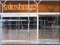
Sainsbury's is closed today
Flooded supermarket in Church Street, in the Caldewgate district of Carlisle.
The water is not very high, looking at the trolleys, but it had already dropped from maximum.
Image: © Rose and Trev Clough
Taken: 6 Dec 2015
0.06 miles
6
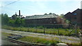
Carlisle Old Brewery Residences
Taken from a train heading south on the West Coast Main Line.
Image: © Richard Cooke
Taken: 17 Jul 2013
0.06 miles
7
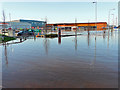
Flooding at Sainsbury's supermarket
The water is not terrifically deep at this stage, but it is covering a low fence which separates the car park from Bridge Lane (right of shrubs and trolley shelter).
Sainsbury's was not there when Carlisle experienced its last major flood in 2005 - the store opened in 2012.
Image: © Rose and Trev Clough
Taken: 6 Dec 2015
0.07 miles
8
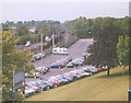
Devonshire Walk Car Park
The car park for the castle, with a freight train passing.
Image: © Stephen Craven
Taken: 16 May 2002
0.07 miles
9
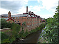
Brewery Residence and the River Caldew
The Brewery Residence is the former Carlisle Old Brewery which has been converted to student residences and a YHA hostel.
Image: © habiloid
Taken: 1 Aug 2016
0.09 miles
10
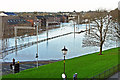
No trains today
The gantries mark the position of the West Coast Main Line railway, submerged beneath floodwater from the River Caldew. The river's normal channel is to the left of the railway, beside the buildings at the Old Brewery.
Devonshire Walk car park is on the right.
Image: © Rose and Trev Clough
Taken: 6 Dec 2015
0.09 miles