IMAGES TAKEN NEAR TO
Windermere Road, CARLISLE, CA2 5RB
Introduction
This page details the photographs taken nearby to Windermere Road, CA2 5RB by members of the Geograph project.
The Geograph project started in 2005 with the aim of publishing, organising and preserving representative images for every square kilometre of Great Britain, Ireland and the Isle of Man.

There are currently over 7.5m images from over14,400 individuals and you can help contribute to the project by visiting https://www.geograph.org.uk
Image Map
Images are licensed for reuse under creativecommons.org/licenses/by-sa/2.0
Notes
- Clicking on the map will re-center to the selected point.
- The higher the marker number, the further away the image location is from the centre of the postcode.
Image Listing (47 Images Found)
Images are licensed for reuse under creativecommons.org/licenses/by-sa/2.0
Image
Details
Distance
1
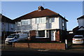
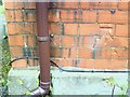
Nos. 32 and 30 Borrowdale Road
There is an OS benchmark Image on the side of the right hand house near its front corner
Image: © Roger Templeman
Taken: 3 Jan 2020
0.05 miles
2
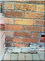
Benchmark on #30 Borrowdale Road
This Ordnance Survey cut mark benchmark is described on the Bench Mark Database at http://www.bench-marks.org.uk/bm34909
Image: © Roger Templeman
Taken: 17 Jul 2010
0.05 miles
4
St Bede's House, Wigton Road
There is an OS benchmark Image on the near corner, right hand face of the house
Image: © Roger Templeman
Taken: 3 Jan 2020
0.08 miles
5
Benchmark on St Bede's Rectory
Ordnance Survey cut mark benchmark on NE face of the rectory. More information on the mark can be found on the Bench Mark Database at http://www.bench-marks.org.uk/bm34921
Image: © Roger Templeman
Taken: 17 Jul 2010
0.08 miles
6
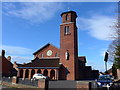
St Bede's RC Church, Carlisle: mid-February 2015
Image: © Basher Eyre
Taken: 17 Feb 2015
0.08 miles
7
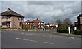
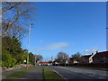
Borrowdale Road, Carlisle
Running north from Dunmail Drive.
Image: © Christine Johnstone
Taken: 11 Apr 2014
0.10 miles
8
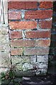
Benchmark on detached garage of #86 Dunmail Drive
Ordnance Survey cut mark benchmark described on the Bench Mark Database at https://www.bench-marks.org.uk/bm114663
Image: © Roger Templeman
Taken: 3 Jan 2020
0.10 miles
9
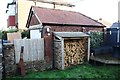
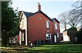
Detached garage at rear of 86 Dunmail Drive
There is an OS benchmark Image on the side of the garage in the bricks left of the log shed
Image: © Roger Templeman
Taken: 3 Jan 2020
0.10 miles
10
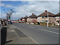
Western end of Dunmail Drive
Looking towards the junction with the A595.
Image: © Christine Johnstone
Taken: 11 Apr 2014
0.12 miles