IMAGES TAKEN NEAR TO
Dalston Road, CARLISLE, CA2 5PL
Introduction
This page details the photographs taken nearby to Dalston Road, CA2 5PL by members of the Geograph project.
The Geograph project started in 2005 with the aim of publishing, organising and preserving representative images for every square kilometre of Great Britain, Ireland and the Isle of Man.

There are currently over 7.5m images from over14,400 individuals and you can help contribute to the project by visiting https://www.geograph.org.uk
Image Map
Images are licensed for reuse under creativecommons.org/licenses/by-sa/2.0
Notes
- Clicking on the map will re-center to the selected point.
- The higher the marker number, the further away the image location is from the centre of the postcode.
Image Listing (58 Images Found)
Images are licensed for reuse under creativecommons.org/licenses/by-sa/2.0
Image
Details
Distance
1
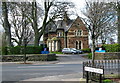
Caldew Hospital
On Dalston Road but viewed from Empire Road.
Image: © David Rogers
Taken: 7 Apr 2009
0.08 miles
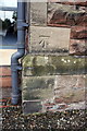
2

Wall of #139 Dalston Road
There is an OS benchmark Image on top of the wall about 2m left of the stone wall piers
Image: © Roger Templeman
Taken: 7 Jul 2015
0.11 miles
3
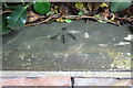
Benchmark on wall of #139 Dalston Road
Ordnance Survey pivot benchmark described on the Bench Mark Database at http://www.bench-marks.org.uk/bm68714
Image: © Roger Templeman
Taken: 7 Jul 2015
0.11 miles
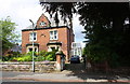
4
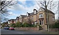
Large semis, north side, Norfolk Road
A private road, gated at the west end.
Image: © Christine Johnstone
Taken: 11 Apr 2014
0.11 miles
5
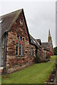
Church hall on St James Road
The spire of St James Church is visible in the background. There is an OS benchmark Image on the corner by the downpipe.
Image: © Roger Templeman
Taken: 7 Aug 2011
0.12 miles
6
Benchmark on Church Hall, St James Road
Ordnance Survey cut mark benchmark described on the Bench Mark Database at http://www.bench-marks.org.uk/bm30965
Image: © Roger Templeman
Taken: 7 Aug 2011
0.12 miles
7
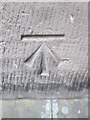
Ordnance Survey Cut Mark
This OS cut mark can be found on the Church Hall. It marks a point 24.387m above mean sea level.
Image: © Adrian Dust
Taken: 12 Apr 2016
0.12 miles
8
#16 Norfolk Road
There is an OS benchmark Image on a post in the wall at the road end of the party wall between Nos. 14/16 Norfolk Road (in the shade right of the right hand gatepost at the house entrance)
Image: © Roger Templeman
Taken: 7 Jul 2015
0.12 miles
9
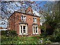
Detached house, Norfolk Road, Carlisle
With an 1882 date stone.
Image: © Christine Johnstone
Taken: 11 Apr 2014
0.12 miles
10
Norfolk Road, Carlisle
A private road, gated at the west end.
Image: © Christine Johnstone
Taken: 11 Apr 2014
0.12 miles