IMAGES TAKEN NEAR TO
Dalston Road, CARLISLE, CA2 5PJ
Introduction
This page details the photographs taken nearby to Dalston Road, CA2 5PJ by members of the Geograph project.
The Geograph project started in 2005 with the aim of publishing, organising and preserving representative images for every square kilometre of Great Britain, Ireland and the Isle of Man.

There are currently over 7.5m images from over14,400 individuals and you can help contribute to the project by visiting https://www.geograph.org.uk
Image Map (Loading...)


Getting Data...Please wait
Leaflet Map data © OpenStreetMap
Images are licensed for reuse under creativecommons.org/licenses/by-sa/2.0
Notes
- Clicking on the map will re-center to the selected point.
- The higher the marker number, the further away the image location is from the centre of the postcode.
Image Listing (50 Images Found)
Images are licensed for reuse under creativecommons.org/licenses/by-sa/2.0
Image
Details
Distance
1

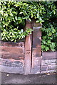
Wall of #139 Dalston Road
There is an OS benchmark Image on top of the wall about 2m left of the stone wall piers
Image: © Roger Templeman
Taken: 7 Jul 2015
0.04 miles
2
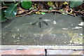
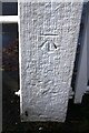
Benchmark on wall of #139 Dalston Road
Ordnance Survey pivot benchmark described on the Bench Mark Database at http://www.bench-marks.org.uk/bm68714
Image: © Roger Templeman
Taken: 7 Jul 2015
0.04 miles
3
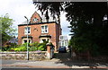
Parkfield Nursery School, Dalston Road
There is an OS benchmark Image on the gatepost.
Image: © Roger Templeman
Taken: 7 Aug 2011
0.06 miles
4
Benchmark on Parkfield Nursery School gatepost, Dalston Road
Ordnance Survey cut mark benchmark described on the Bench Mark Database at http://www.bench-marks.org.uk/bm39072
Image: © Roger Templeman
Taken: 7 Aug 2011
0.06 miles
5

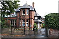
Detached house, Norfolk Road, Carlisle
With an 1882 date stone.
Image: © Christine Johnstone
Taken: 11 Apr 2014
0.08 miles
6
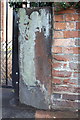
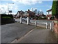
#16 Norfolk Road
There is an OS benchmark Image on a post in the wall at the road end of the party wall between Nos. 14/16 Norfolk Road (in the shade right of the right hand gatepost at the house entrance)
Image: © Roger Templeman
Taken: 7 Jul 2015
0.08 miles
7
Benchmark on wall post of #16 Norfolk Road
Ordnance Survey cut mark benchmark described on the Bench Mark Database at http://www.bench-marks.org.uk/bm39073
Image: © Roger Templeman
Taken: 7 Aug 2011
0.08 miles
9
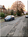
Western end of Norfolk Road, Carlisle
Gated to prevent vehicle access to and from the B5299.
Image: © Christine Johnstone
Taken: 11 Apr 2014
0.09 miles
10
Benchmark on gatepost at west end of Norfolk Road
Ordnance Survey cut mark benchmark shown on the 1901 1:2500 Map as levelled at 87.1 feet above Liverpool Datum
Image: © Roger Templeman
Taken: 23 Oct 2020
0.09 miles