IMAGES TAKEN NEAR TO
St. James Avenue, CARLISLE, CA2 5PE
Introduction
This page details the photographs taken nearby to St. James Avenue, CA2 5PE by members of the Geograph project.
The Geograph project started in 2005 with the aim of publishing, organising and preserving representative images for every square kilometre of Great Britain, Ireland and the Isle of Man.

There are currently over 7.5m images from over14,400 individuals and you can help contribute to the project by visiting https://www.geograph.org.uk
Image Map
Images are licensed for reuse under creativecommons.org/licenses/by-sa/2.0
Notes
- Clicking on the map will re-center to the selected point.
- The higher the marker number, the further away the image location is from the centre of the postcode.
Image Listing (59 Images Found)
Images are licensed for reuse under creativecommons.org/licenses/by-sa/2.0
Image
Details
Distance
1
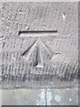
Ordnance Survey Cut Mark
This OS cut mark can be found on the Church Hall. It marks a point 24.387m above mean sea level.
Image: © Adrian Dust
Taken: 12 Apr 2016
0.07 miles
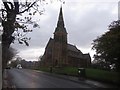
2
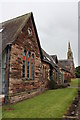
Church hall on St James Road
The spire of St James Church is visible in the background. There is an OS benchmark Image on the corner by the downpipe.
Image: © Roger Templeman
Taken: 7 Aug 2011
0.07 miles
3
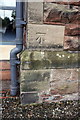
Benchmark on Church Hall, St James Road
Ordnance Survey cut mark benchmark described on the Bench Mark Database at http://www.bench-marks.org.uk/bm30965
Image: © Roger Templeman
Taken: 7 Aug 2011
0.07 miles
4
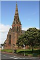
St James's Church, St James' Road
The church spire is an Ordnance Survey intersected station trig point, see http://trigpointing.uk/trig/11110
Image: © Roger Templeman
Taken: 19 Aug 2019
0.08 miles
5
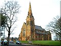
St. James's Church, Longsowerby
Situated on St. James Road, the church opened in 1867.
Image: © Rose and Trev Clough
Taken: 6 Apr 2008
0.08 miles
6
St James Church, St James Road, Carlisle
St James Church in the Longsowerby part of Carlisle. The church dates from around 1865 and was designed by Anderson and Pepper of Bradford. The building is grade II listed.
Image: © Graham Robson
Taken: 30 Oct 2014
0.09 miles
7
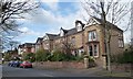
Large semis, north side, Norfolk Road
A private road, gated at the west end.
Image: © Christine Johnstone
Taken: 11 Apr 2014
0.09 miles
8
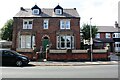
No. 34 St James Road, 'The Limes'
There is an Ordnance Survey benchmark Image on the corner wall pier at the right hand end of the wall fronting the house
Image: © Roger Templeman
Taken: 19 Aug 2019
0.09 miles
9

Houses at the east end of Norfolk Road
There is an OS benchmark Image on top of the wall above the blue book on the pavement
Image: © Roger Templeman
Taken: 7 Jul 2015
0.09 miles
10

Benchmark on Holme View House wall, Norfolk Road
Ordnance Survey pivot benchmark described on the Bench Mark Database at http://www.bench-marks.org.uk/bm39016
Image: © Roger Templeman
Taken: 7 Aug 2011
0.09 miles