IMAGES TAKEN NEAR TO
Clifton Street, CARLISLE, CA2 5NG
Introduction
This page details the photographs taken nearby to Clifton Street, CA2 5NG by members of the Geograph project.
The Geograph project started in 2005 with the aim of publishing, organising and preserving representative images for every square kilometre of Great Britain, Ireland and the Isle of Man.

There are currently over 7.5m images from over14,400 individuals and you can help contribute to the project by visiting https://www.geograph.org.uk
Image Map
Images are licensed for reuse under creativecommons.org/licenses/by-sa/2.0
Notes
- Clicking on the map will re-center to the selected point.
- The higher the marker number, the further away the image location is from the centre of the postcode.
Image Listing (73 Images Found)
Images are licensed for reuse under creativecommons.org/licenses/by-sa/2.0
Image
Details
Distance
1
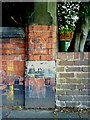
Benchmark on wall pier in St James Road
Ordnance Survey cut mark benchmark on light coloured stone in brick wall pier. More information about the mark may be found on the Bench Mark Database at http://www.bench-marks.org.uk/bm34947
Image: © Roger Templeman
Taken: 17 Jul 2010
0.05 miles
2
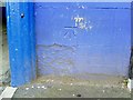
Benchmark on wall in Nelson Street
Ordnance Survey cut mark benchmark on stone in brick wall of United Utilities. More information about the mark may be found on the Bench Mark Database at http://www.bench-marks.org.uk/bm34949
Image: © Roger Templeman
Taken: 17 Jul 2010
0.05 miles
3
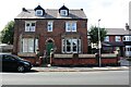
No. 34 St James Road, 'The Limes'
There is an Ordnance Survey benchmark Image on the corner wall pier at the right hand end of the wall fronting the house
Image: © Roger Templeman
Taken: 19 Aug 2019
0.05 miles
4
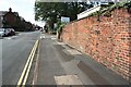
Looking NW along Nelson Street
There is an Ordnance Survey benchmark Image on a stone at the base of the brick wall near the right hand edge of the image
Image: © Roger Templeman
Taken: 19 Aug 2019
0.06 miles
5
Benchmark at Atlas Works entrance
Ordnance Survey cut mark benchmark on Atlas Works, Nelson Street. More information about the mark may be found on the Bench Mark Database at http://www.bench-marks.org.uk/bm34948.
Image: © Roger Templeman
Taken: 17 Jul 2010
0.08 miles
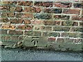
6
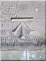
Ordnance Survey Cut Mark
This OS cut mark can be found on the Church Hall. It marks a point 24.387m above mean sea level.
Image: © Adrian Dust
Taken: 12 Apr 2016
0.11 miles
7
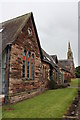
Church hall on St James Road
The spire of St James Church is visible in the background. There is an OS benchmark Image on the corner by the downpipe.
Image: © Roger Templeman
Taken: 7 Aug 2011
0.11 miles
8
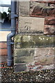
Benchmark on Church Hall, St James Road
Ordnance Survey cut mark benchmark described on the Bench Mark Database at http://www.bench-marks.org.uk/bm30965
Image: © Roger Templeman
Taken: 7 Aug 2011
0.11 miles
9
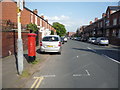
Nelson Street, Carlisle
Showing position of Postbox No. CA2 11.
See Image] for postbox.
Image: © JThomas
Taken: 28 May 2016
0.11 miles
10
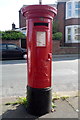
George VI postbox on Nelson Street, Carlisle
Postbox No. CA2 11.
See Image] for context.
Image: © JThomas
Taken: 28 May 2016
0.11 miles