IMAGES TAKEN NEAR TO
Bousteads Grassing, CARLISLE, CA2 5LQ
Introduction
This page details the photographs taken nearby to Bousteads Grassing, CA2 5LQ by members of the Geograph project.
The Geograph project started in 2005 with the aim of publishing, organising and preserving representative images for every square kilometre of Great Britain, Ireland and the Isle of Man.

There are currently over 7.5m images from over14,400 individuals and you can help contribute to the project by visiting https://www.geograph.org.uk
Image Map
Images are licensed for reuse under creativecommons.org/licenses/by-sa/2.0
Notes
- Clicking on the map will re-center to the selected point.
- The higher the marker number, the further away the image location is from the centre of the postcode.
Image Listing (79 Images Found)
Images are licensed for reuse under creativecommons.org/licenses/by-sa/2.0
Image
Details
Distance
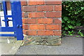
1

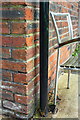
Houses on Bousteads Grassings
There is an OS benchmark Image on the corner, right hand face, of the near house, behind the black downpipe
Image: © Roger Templeman
Taken: 7 Jul 2015
0.02 miles
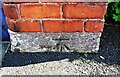
2
Benchmark on #15 Bousteads Grassings
Ordnance Survey cut mark benchmark described on the Bench Mark Database at http://www.bench-marks.org.uk/bm39068
Image: © Roger Templeman
Taken: 7 Aug 2011
0.02 miles
3
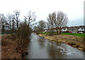
River Caldew View
Looking downstream on a dullish January day with Denton Holme on the left and Bousteads Grassing on the right. The river was still running brown after recent floods.
Image: © Mary and Angus Hogg
Taken: 23 Jan 2016
0.03 miles
4
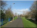
The Cumbria Way near Denton Street
The Cumbria Way long distance path follows the Caldew Cycleway beside the River Caldew near Denton Street (next photograph Image).
Image: © Adrian Taylor
Taken: 11 Mar 2019
0.05 miles
5
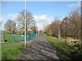
The Caldew Cycleway
The Caldew Cycleway is also the route of The Cumbria Way long distance path (next photograph Image).
The River Caldew is on the right and there is a children’s play area behind the green and blue fencing.
Image: © Adrian Taylor
Taken: 11 Mar 2019
0.06 miles
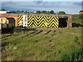
7
Benchmark at entrance to Carlisle City Council garage
Ordnance Survey cut mark benchmark described on the Bench Mark Database at http://www.bench-marks.org.uk/bm38725
Image: © Roger Templeman
Taken: 26 Jun 2011
0.08 miles
8
Benchmark on gatepost base at entrance to Council depot yard, Boustead's Grassing
Ordnance Survey cut mark benchmark described on the Bench Mark Database at www.bench-marks.org.uk/bm38725
Image: © Roger Templeman
Taken: 15 Sep 2020
0.08 miles
9
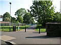
The Cumbria Way, Denton Holme
At the end of Denton Street the Cumbria Way follows the Caldew Cycleway beside the River Caldew (next photograph Image).
The projecting parapets on the right are at the northwest end of a footbridge over the river.
Image: © Adrian Taylor
Taken: 21 May 2018
0.08 miles
10
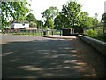
The end of Denton Street
Denton Street ends in a wide turning area regularly used as a car park by local dog walkers.
The Cumbria Way long distance path crosses this area to continue along the Caldew Cycleway, passing between the litter bin and the end of the footbridge parapets (next photograph Image).
Image: © Adrian Taylor
Taken: 21 May 2018
0.09 miles