IMAGES TAKEN NEAR TO
North Street, CARLISLE, CA2 5LN
Introduction
This page details the photographs taken nearby to North Street, CA2 5LN by members of the Geograph project.
The Geograph project started in 2005 with the aim of publishing, organising and preserving representative images for every square kilometre of Great Britain, Ireland and the Isle of Man.

There are currently over 7.5m images from over14,400 individuals and you can help contribute to the project by visiting https://www.geograph.org.uk
Image Map
Images are licensed for reuse under creativecommons.org/licenses/by-sa/2.0
Notes
- Clicking on the map will re-center to the selected point.
- The higher the marker number, the further away the image location is from the centre of the postcode.
Image Listing (78 Images Found)
Images are licensed for reuse under creativecommons.org/licenses/by-sa/2.0
Image
Details
Distance
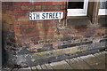
1
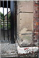
Benchmark on the archway side of #19 North Street
Ordnance Survey pivot benchmark described on the Bench Mark Database at http://www.bench-marks.org.uk/bm39015
Image: © Roger Templeman
Taken: 7 Aug 2011
0.00 miles
2
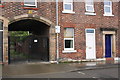
Arched gated entrance beside #19 North Street
On the white base of the archway side next to the lamp post is an OS benchmark Image
Image: © Roger Templeman
Taken: 7 Aug 2011
0.00 miles
3
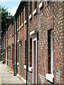
Bridge Terrace, Denton Holme
Bridge Terrace was built in 1852-3 to provide housing for workers at the nearby textile mill. It is now grade II listed.
Image: © Stephen McKay
Taken: 20 Jun 2008
0.04 miles
4
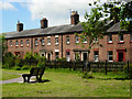
Bridge Terrace, Denton Holme
The houses were built in the 1850s for workers at the nearby Ferguson Bros textile mill. In the front of the houses there is an open space that was at one time a bowling green provided by the company.
Image: © Stephen McKay
Taken: 20 Jun 2008
0.05 miles
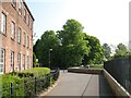
5
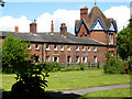
Bridge Terrace, Denton Holme
Bridge Terrace was built in the 1850s for workers at the nearby Ferguson Bros textile mill. The distinctive building at the end of the terrace was a coffee tavern and reading room opened in 1882 by the company for its workforce.
Image: © Stephen McKay
Taken: 20 Jun 2008
0.05 miles
6
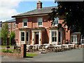
The Bay, Denton Holme
Now a pub, this building was originally the house of the works manager of Ferguson Bros textile mill. The company set up here, taking advantage of the waters of the River Caldew to provide power, in 1828; the mill finally closed in 1991 with 200 redundancies. The name of the pub refers to the 'bay' in the river built to regulate flow into the mill race.
Image: © Stephen McKay
Taken: 20 Jun 2008
0.05 miles
7
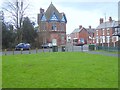
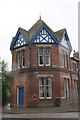
Octagonal house in Denton Holme
On the edge of the built-up area.
Image: © Oliver Dixon
Taken: 25 Jan 2016
0.05 miles
8
Carlisle City Amateur Swimming Club clubhouse, North Street
On the window by the road name sign is an OS benchmark Image The letter box is EIIR.
Image: © Roger Templeman
Taken: 7 Aug 2011
0.05 miles
9
Benchmark on Swimming Club clubhouse, North Street
Ordnance Survey cut mark benchmark described on the Bench Mark Database at http://www.bench-marks.org.uk/bm39069
Image: © Roger Templeman
Taken: 7 Aug 2011
0.05 miles
10
The Cumbria Way by The Mill at Holme Head
The Cumbria Way long distance path follows the Caldew Cycleway beside the Grade II Listed former Ferguson Brothers Mill at Holme Head Works (next photograph Image).
Image: © Adrian Taylor
Taken: 21 May 2018
0.06 miles