IMAGES TAKEN NEAR TO
McIlmoyle Way, CARLISLE, CA2 5GY
Introduction
This page details the photographs taken nearby to McIlmoyle Way, CA2 5GY by members of the Geograph project.
The Geograph project started in 2005 with the aim of publishing, organising and preserving representative images for every square kilometre of Great Britain, Ireland and the Isle of Man.

There are currently over 7.5m images from over14,400 individuals and you can help contribute to the project by visiting https://www.geograph.org.uk
Image Map
Images are licensed for reuse under creativecommons.org/licenses/by-sa/2.0
Notes
- Clicking on the map will re-center to the selected point.
- The higher the marker number, the further away the image location is from the centre of the postcode.
Image Listing (106 Images Found)
Images are licensed for reuse under creativecommons.org/licenses/by-sa/2.0
Image
Details
Distance
3
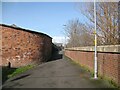
The Cumbria Way, Metcalfe Street
Passing beside the curved wall of a garage at the end of Metcalfe Street, The Cumbria Way long distance path follows the Caldew Cycleway along the back of the River Caldew flood defence wall at Denton Holme (next photograph Image). This section of the Caldew Cycleway is also known as the Caldew Riverside Trail.
Image: © Adrian Taylor
Taken: 11 Mar 2019
0.05 miles
4
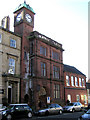
Art Gallery, Carlisle
It is located along Castle Street
Image: © Kenneth Allen
Taken: 8 Oct 2009
0.05 miles
5
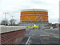
Carlisle Gas Works - March 2018
No longer producing gas, but now the site of a recycling centre.
Image: © The Carlisle Kid
Taken: 26 Mar 2018
0.06 miles
6
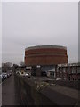
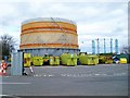
Gas holder, Rome Street
Built in 1928, dismantled 2018 - see Image .
On the left is a flood wall, beside the River Caldew. The car park is for staff based at the City Council works depot in Bousteads Grassing.
Image: © Rose and Trev Clough
Taken: 21 Feb 2009
0.06 miles
7
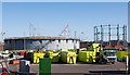
Demolition of gas holder in progress
Located in Rome Street. A photo of the gas holder in its expanded state can be seen here Image .
Gas holders were originally built to store locally produced coal gas - this one dates from 1928 (News & Star 05.10.18 http://www.newsandstar.co.uk/news/16967619.landmark-gasometer-demolished-in-carlisle/ ). Later they were used to store natural gas for times of peak demand, such as early evenings and cold weather. Advances in technology have increased the efficiency of the modern-day gas network, so these storage facilities have become redundant.
The framework of a Victorian gas holder on the other side of Rome Street (photo here https://www.geograph.org.uk/photo/856391 ) will remain, because it is a listed building.
For a closer look, see Image .
Image: © Rose and Trev Clough
Taken: 3 Oct 2018
0.07 miles
8
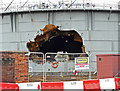
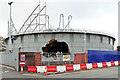
There's a big hole in the gas holder
The structure is being demolished because the storage facility is no longer needed for today's efficient gas network.
Another hole can be seen on the far side of the gas holder. These were cut to allow access to the water tank in the bottom of the structure, which needed to be drained before demolition could proceed (note the two lifebuoys).
For a wider view of the location and more information, see Image .
Image: © Rose and Trev Clough
Taken: 3 Oct 2018
0.07 miles
9
Household Waste Recycling Centre, Bousteads Grassing
Previously known as The Tip. In the hut a man with a stripy leg keeps watch, to make sure no trade waste enters the site. Ordinary householders who wish to transport their rubbish in a van or trailer, or on foot, must obtain a permit. Carlisle residents are currently sending more than 50% of household waste for recycling, mainly by kerbside collection.
Image: © Rose and Trev Clough
Taken: 18 Mar 2008
0.07 miles