IMAGES TAKEN NEAR TO
Teasdale Place, CARLISLE, CA2 5FZ
Introduction
This page details the photographs taken nearby to Teasdale Place, CA2 5FZ by members of the Geograph project.
The Geograph project started in 2005 with the aim of publishing, organising and preserving representative images for every square kilometre of Great Britain, Ireland and the Isle of Man.

There are currently over 7.5m images from over14,400 individuals and you can help contribute to the project by visiting https://www.geograph.org.uk
Image Map
Images are licensed for reuse under creativecommons.org/licenses/by-sa/2.0
Notes
- Clicking on the map will re-center to the selected point.
- The higher the marker number, the further away the image location is from the centre of the postcode.
Image Listing (76 Images Found)
Images are licensed for reuse under creativecommons.org/licenses/by-sa/2.0
Image
Details
Distance
2
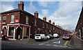
Westmorland Street, Carlisle
Somebody likes to be noticed. Looking north from Norfolk Street.
Image: © Christine Johnstone
Taken: 11 Apr 2014
0.06 miles
3
Norfolk Court, Norfolk Street, Carlisle
Former business premises? Now flats and retail units.
Image: © Christine Johnstone
Taken: 11 Apr 2014
0.06 miles
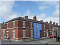
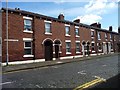
4
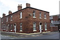
Houses on Westmorland Street at Norfolk Street junction
Image: © Roger Templeman
Taken: 7 Jul 2015
0.07 miles
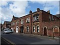
5
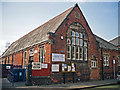
Denton Holme Community Centre
The centre has a main hall, library (part-time opening), lounge, kitchen and meeting room (website : http://www.dentonholmecommunitycentre.org.uk/ ).
The building was part of Morley Street School, the rest of which has been demolished.
Image: © Rose and Trev Clough
Taken: 29 Apr 2014
0.07 miles
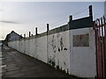
6
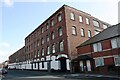
Atlas Works, Nelson Street
The building houses businesses including Border Warrior and Cumbria Dance as well as workshop and warehouse units. There is an Ordnance Survey benchmark Image on the face of the building right of the entrance arch
Image: © Roger Templeman
Taken: 19 Aug 2019
0.07 miles
7
Colville Street, Carlisle
Looking north from Norfolk Street.
Image: © Christine Johnstone
Taken: 11 Apr 2014
0.07 miles
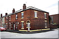
8
Junction of Norfolk Street and Colville Street
There is an OS benchmark Image on the white skirt on the corner, right hand face, of the nearest house
Image: © Roger Templeman
Taken: 7 Jul 2015
0.08 miles
9
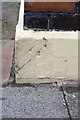
Benchmark on skirt of #26 Norfolk Street
Ordnance Survey pivot benchmark described on the Bench Mark Database at http://www.bench-marks.org.uk/bm68715
Image: © Roger Templeman
Taken: 7 Jul 2015
0.08 miles
10
Westmorland Street, Carlisle
Looking south from Norfolk Street.
Image: © Christine Johnstone
Taken: 11 Apr 2014
0.08 miles