IMAGES TAKEN NEAR TO
Denton Street, CARLISLE, CA2 5DY
Introduction
This page details the photographs taken nearby to Denton Street, CA2 5DY by members of the Geograph project.
The Geograph project started in 2005 with the aim of publishing, organising and preserving representative images for every square kilometre of Great Britain, Ireland and the Isle of Man.

There are currently over 7.5m images from over14,400 individuals and you can help contribute to the project by visiting https://www.geograph.org.uk
Image Map
Images are licensed for reuse under creativecommons.org/licenses/by-sa/2.0
Notes
- Clicking on the map will re-center to the selected point.
- The higher the marker number, the further away the image location is from the centre of the postcode.
Image Listing (216 Images Found)
Images are licensed for reuse under creativecommons.org/licenses/by-sa/2.0
Image
Details
Distance
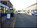
1
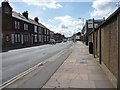
Bus stop on Denton Street, Carlisle
Looking south towards the raised pavement, from the junction with Thomas Street.
Image: © Christine Johnstone
Taken: 11 Apr 2014
0.01 miles
2
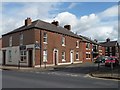
New and old homes on Thomas Street, Carlisle
Looking east from Denton Street.
Image: © Christine Johnstone
Taken: 11 Apr 2014
0.02 miles
3
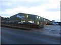
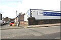
Retail showroom, Denton Street, Carlisle
A retail showroom belonging to a seller of timber products, on Denton Street.
Image: © Graham Robson
Taken: 30 Oct 2014
0.03 miles
4
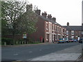
Lime Street, Carlisle
Numbers 17 to 33, as the rest have been demolished.
Image: © Stuart Irving
Taken: 6 May 2008
0.05 miles
5
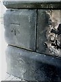
Benchmark on bridge at junction of Lorne Street and Victoria Viaduct
Ordnance Survey cut mark benchmark which is described in detail on the Bench Mark Database at http://www.bench-marks.org.uk/bm30966
Image: © Roger Templeman
Taken: 17 Jul 2010
0.05 miles
6
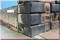
Benchmark on railway bridge, Victoria Viaduct
Ordnance Survey cut mark benchmark described on the Bench Mark Database at http://www.bench-marks.org.uk/bm30966
Image: © Roger Templeman
Taken: 7 Aug 2011
0.05 miles
8
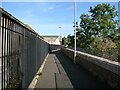
The Cumbria Way, Denton Holme
The Cumbria Way long distance path follows the Caldew Cycleway along the back of the River Caldew flood defence wall at Denton Holme (next photograph Image). This section of the Caldew Cycleway is also known as the Caldew Riverside Trail.
Denton Holme can also be spelled as Dentonholme; the various railway companies that maintained facilities in this part of Carlisle almost exclusively used Dentonholme, Denton Holme is more common elsewhere.
Image: © Adrian Taylor
Taken: 28 Sep 2013
0.06 miles
9

Former "Denton Inn", Denton Street - March 2018
State Management Scheme records suggest 50 Denton Street was the site of the "Denton Inn", possibly also known as "Denton Wines Stores", which was sold to Scottish & Newcastle on 16 April 1973. It may have been a replacement for the earlier "Denton Inn" at 110 Denton Street (see: Image] ) which closed in 1927 following an adverse police report. More research is required.
There are no numbers on any of these premises, but 50 should be the middle shop. However, the actual Inn/off-licence could have been larger, with subsequent re-numbering. Date of closure has not been found.
Photograph is for record only – I have no connection with any business seen in this view and cannot advise on their products or services.
Image: © The Carlisle Kid
Taken: 9 Mar 2018
0.07 miles
10
Junction of Denton Street and Lorne Street and Denton Tyres Depot
Image: © Roger Templeman
Taken: 19 Aug 2019
0.07 miles