IMAGES TAKEN NEAR TO
Sheffield Street, CARLISLE, CA2 5DT
Introduction
This page details the photographs taken nearby to Sheffield Street, CA2 5DT by members of the Geograph project.
The Geograph project started in 2005 with the aim of publishing, organising and preserving representative images for every square kilometre of Great Britain, Ireland and the Isle of Man.

There are currently over 7.5m images from over14,400 individuals and you can help contribute to the project by visiting https://www.geograph.org.uk
Image Map
Images are licensed for reuse under creativecommons.org/licenses/by-sa/2.0
Notes
- Clicking on the map will re-center to the selected point.
- The higher the marker number, the further away the image location is from the centre of the postcode.
Image Listing (385 Images Found)
Images are licensed for reuse under creativecommons.org/licenses/by-sa/2.0
Image
Details
Distance
1
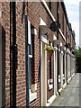
Sheffield Street, Carlisle
A tidy row of Victorian terraced houses on this dead-end street.
Image: © Stephen McKay
Taken: 20 Jun 2008
0.00 miles
2

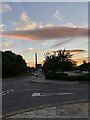
Sheffield Street, Carlisle
Looking north-west from Denton Street, as it rises up to the Victoria viaduct.
Image: © Christine Johnstone
Taken: 11 Apr 2014
0.01 miles
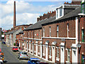
3
Randall Street, Carlisle
Seen from the junction with Sheffield Street.
Image: © Stephen McKay
Taken: 20 Jun 2008
0.02 miles
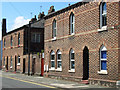
4
Sheffield Street, Carlisle
Street of Victorian terraced houses accessed at the east end by steps from Victoria Viaduct.
Image: © Stephen McKay
Taken: 20 Jun 2008
0.02 miles
5
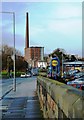
Charlotte Street, Carlisle
Looking along Charlotte Street from Nelson Bridge. The prominent landmarks of Dixon's chimney and Shaddon Mill are shown in the background. For more information, see Image
Image: © Mary and Angus Hogg
Taken: 18 Feb 2012
0.03 miles
6
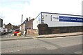
Junction of Denton Street and Lorne Street and Denton Tyres Depot
Image: © Roger Templeman
Taken: 19 Aug 2019
0.03 miles
8
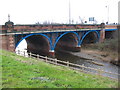
Nelson Bridge
A view looking to the southwest from the Viaduct carpark towards Nelson Bridge over the River Caldew.
Image: © Phil Williams
Taken: 15 Feb 2007
0.04 miles
9
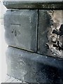
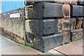
Benchmark on bridge at junction of Lorne Street and Victoria Viaduct
Ordnance Survey cut mark benchmark which is described in detail on the Bench Mark Database at http://www.bench-marks.org.uk/bm30966
Image: © Roger Templeman
Taken: 17 Jul 2010
0.05 miles
10
Benchmark on railway bridge, Victoria Viaduct
Ordnance Survey cut mark benchmark described on the Bench Mark Database at http://www.bench-marks.org.uk/bm30966
Image: © Roger Templeman
Taken: 7 Aug 2011
0.05 miles