IMAGES TAKEN NEAR TO
Red Beck Road, CLEATOR MOOR, CA25 5HH
Introduction
This page details the photographs taken nearby to Red Beck Road, CA25 5HH by members of the Geograph project.
The Geograph project started in 2005 with the aim of publishing, organising and preserving representative images for every square kilometre of Great Britain, Ireland and the Isle of Man.

There are currently over 7.5m images from over14,400 individuals and you can help contribute to the project by visiting https://www.geograph.org.uk
Image Map (Loading...)


Getting Data...Please wait
Leaflet Map data © OpenStreetMap
Images are licensed for reuse under creativecommons.org/licenses/by-sa/2.0
Notes
- Clicking on the map will re-center to the selected point.
- The higher the marker number, the further away the image location is from the centre of the postcode.
Image Listing (2 Images Found)
Images are licensed for reuse under creativecommons.org/licenses/by-sa/2.0
Image
Details
Distance
1
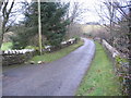
Bridge over Windergill Beck.
Poor planning to have to put the telegraph pole just there.
Image: © John Holmes
Taken: 11 Dec 2005
0.01 miles
2
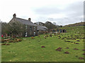
High Waterside Farm
Just inside the boundary of the Lake District National Park in the Ehen Valley.
Image: © John Allan
Taken: 17 Apr 2018
0.24 miles